
But like all plans, a plan is good only until first contact with the enemy. For Dauntless it’s headwinds, or better said, for Richard it’s the hobby horse ride headwinds produce on Dauntless. The fact that we are consuming half of our fuel, just to go up and down waves, adds to the sick feeling the ride produces.
Yep, it’s a lose, lose, lose situation for all: the timeline, my wallet and my health.
Dauntless in the meantime just motors along, oblivious to my misery.
For my long range planning, other than Jimmy Cornell’s books and pilot charts, on a daily basis I pretty much only look at this: link to current Atlantic map
This shows the current surface winds over the Atlantic. You can see that draw a line from Gibraltar to the Canaries to Barbados and the trade winds are running strong as they have all winter. So no problems there.
(side note, there is simply no point in looking at anything more specific for any period more than two weeks away. Even when I was waiting to cross the North Sea from Norway to Scotland, a three-day trip, I read the marine forecast, but really only looked at this site to figure out when I would have at least a two-day window, which is what I got)
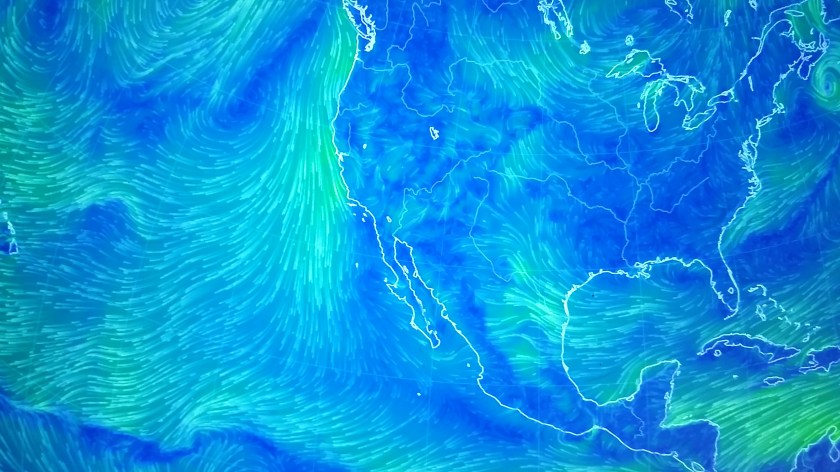
Now, this is the problem, this is the Eastern Pacific, link to current western Pacific map
I’ve been looking at this about once a day since fall. Only in the past month have the northerly winds let up south of Mexico and Central America.
My current 15-month plan would require me to be able to travel north from the Panama Canal to Kodiak Alaska in 170 days or about 35 miles per day. Doable with favorable winds, but I’ve been watching and the winds are not favorable, not at all. At this point, at best, I think a quarter of the days would be “good” cruising days and that may be too generous.
The other problem with this current plan is that I would probably be able to rush north out of Central America, but then get stuck in Mexico and the coast of the western U.S. for months on end. Thus passing by places I would like to spend time only to be stuck in places I don’t.
So, Plan B.
I will add a year to the Cruise Plan, wintering in Southeast Alaska.
Many boaters do it, I know it somewhat, but only from the perspective of the Alaska Marine Highway (Ferry) system.
Thus I can spend more time in Central America at the height of the winter when the northerlies are strongest and I can spend 10 months in British Columbia and Southeast Alaska, some of the prettiest cruising areas in the world, full of fjords, whales, birds and bears!
The weather is not that bad and having visited Juneau and Sitka many times back in the 90’s, it will be nice to go back on my own bottom.
