I thought this would be a good opportunity to explain my weather planning or better said, planning on the weather.
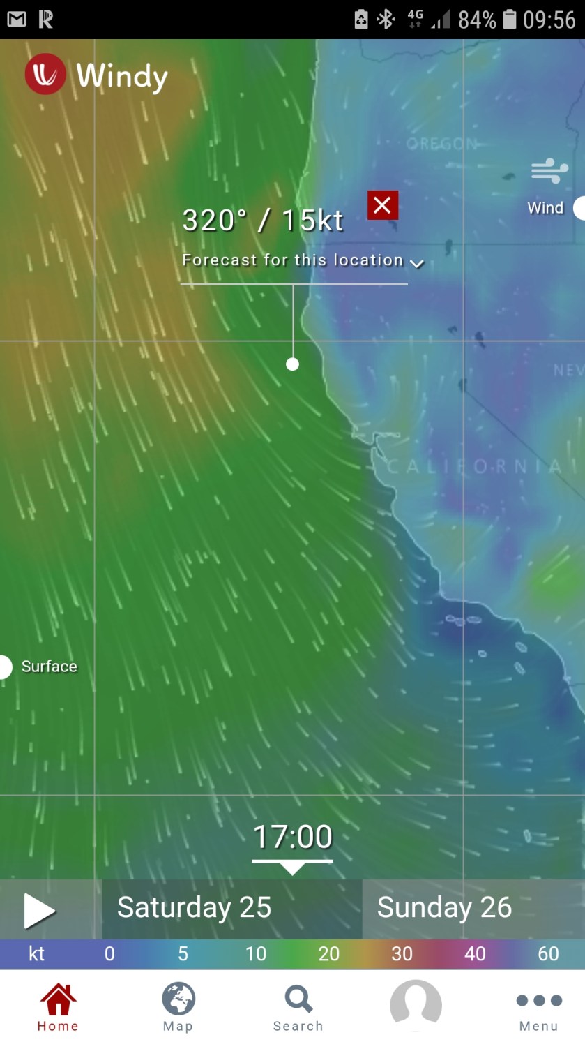
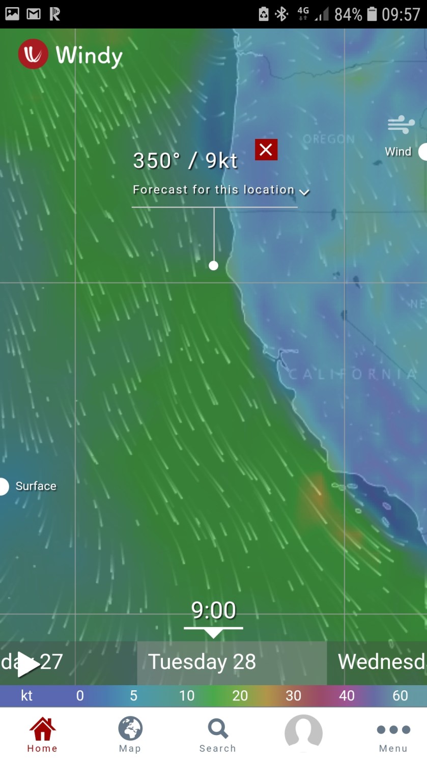
The fist picture on the left shows my main area of interest at the white dot, just south of Cape Mendocino. This is where the winds are the strongest. It’s a two day (46 hr) cruise to Crescent City, just north of that spot.
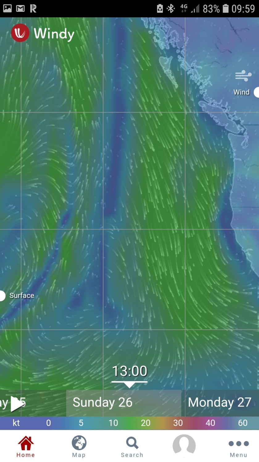
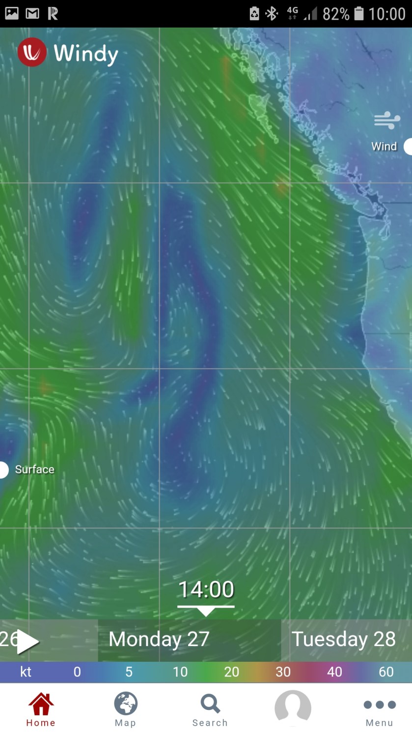
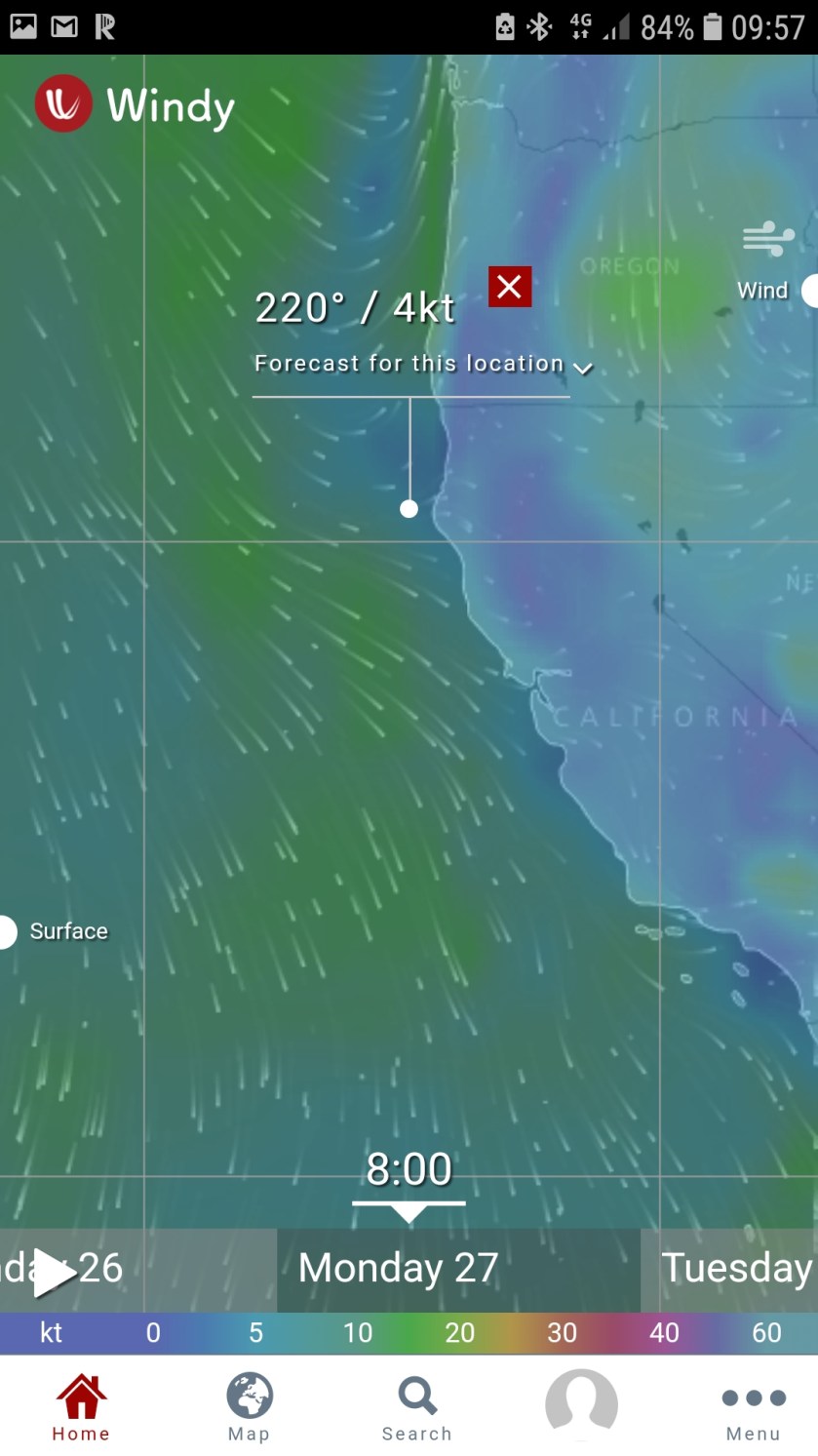
The sequnece from the 25th to the 28th seems to show improving condidions along the sure, with the strong Northerly winds moving off shore.
It could well happen. But what I focus on is the large overall pattern.
So while it is showing a small area of light winds along the coast, that if it came to pass as depicted, it would be ok, even good to leave San Francisco and head north, the problem is the area of favorable winds is very small.
I’ve always said that forecasts are more often correct, but id they are wrong, it’s usually an issue of location or time, but not the event. For example, a cold front with showers and thunderstorms is forecast to move thru your area in 12 houris time. In reality, it could be 10 hours, or 8 hours, even 6.but it’s happened.
Where it happened is another story, That’s what I mean my location. Forecasting snow anywhere along the east coast is always problematic. A lot of things ahve to fall in place for the forecast to be spot on at a given location or time. The snow-rain line could end up being 10 miles west of New York City. After the news media has panicked everyone for days, it looks\ like a big bust, but in reality, looking at the large scale picture, 90% of the areas that were forecast to get snow got it, same for rain, it was only that little band that was incorrect.
And that’s what I’m thinking of as I look at these three days of forecasts. The overall pattern really doesn’t change much. This little narrow area of light winds could easily end up being 20 miles to the east leaving me frighting winds and waves.
Most importantly, all the pictures I have posted here are the only things I have looked at to make this decision. This gives me an overview. Until the overview looks more than doable, there is not point in in spending time looking elsewhere, at other products or other models.
Om addition, if you find yourself trying to find the right model to five you the forecast you want, you are only cruising for a bruising.
Two days ago, here are the Windycom woeather maps I looked at to tmake my decision if 23 could leave on the 25th:


It’s 7 days to Washington’s Neah Bay. The first few are the most critical, since off the Oregon coast, the winds are more from the southwest in general. So, the California portion is the most difficult.
I’ll wait until the entire high pressure system moves east. I’d rather have 30 knots from the SW than 10 knots from the north.

Hi
A suggestion if the weather window is short to Crescent City. Go into Bodega Bay (no Bar) in order to get out of S.F. on the proper tides etc. Then leave when weather good.
Outside of C.C. are usually so many crab traps you could walk across water on them. They seem to be there even if crab season not open. Off shore beyond 100 fathoms they usually go away.
Rounding Mendocino it doesn’t really matter if close in by buoys or far out. It is always rocking and rolling. I usually stayed close in order to make it as short a trip as possible.
Keep in mind when heading north from C.C. the next small cape, Cape Blanco, has always been a rough ride, because the natural route out of C.C. is to angel up to it in a NW direction, before turning north. Consequently you are close inshore. I’ve been beaten up there worse than at Mendocino! Also some reefs with no markers extend offshore just north of C.C., zoom in on chart to see them to be sure you’re not going over them.
On another note, The NOAA weather station in Eureka, you can call and ask to speak to the weatherman on duty. They will put you through to someone there, and you can ask them questions about the forecast etc. They are a friendly group, and you’re getting personal weather information FREE. If you happened to go in there, they will take you into the back room and show you how they do the forecasting. It is very interesting!
Apologize, don’t mean to tell you what to do etc. Just trying to help.
Chuck Herr
m/v Wily King
760-518-6744
From: Dauntless at Sea
Reply-To: Dauntless at Sea
Date: Tuesday, May 21, 2019 at 20:22
To: Chuck Herr
Subject: [New post] Weather Planning
Richard on Dauntless posted: “I thought this would be a good opportunity to explain my weather planning or better said, planning on the weather. The fist picture on the left shows my main area of interest at the white dot, just south of Cape Mendocino. This is where the winds are t”
Two days ago, it looked like I was going exactly that, as a weather window opened up near the end of next week. I would have left on Friday or Saturday and then waited in BB for the winds to subside late Sunday.
That window disappeared yesterday.