I thought this would be a good opportunity to explain my weather planning or better said, planning on the weather.
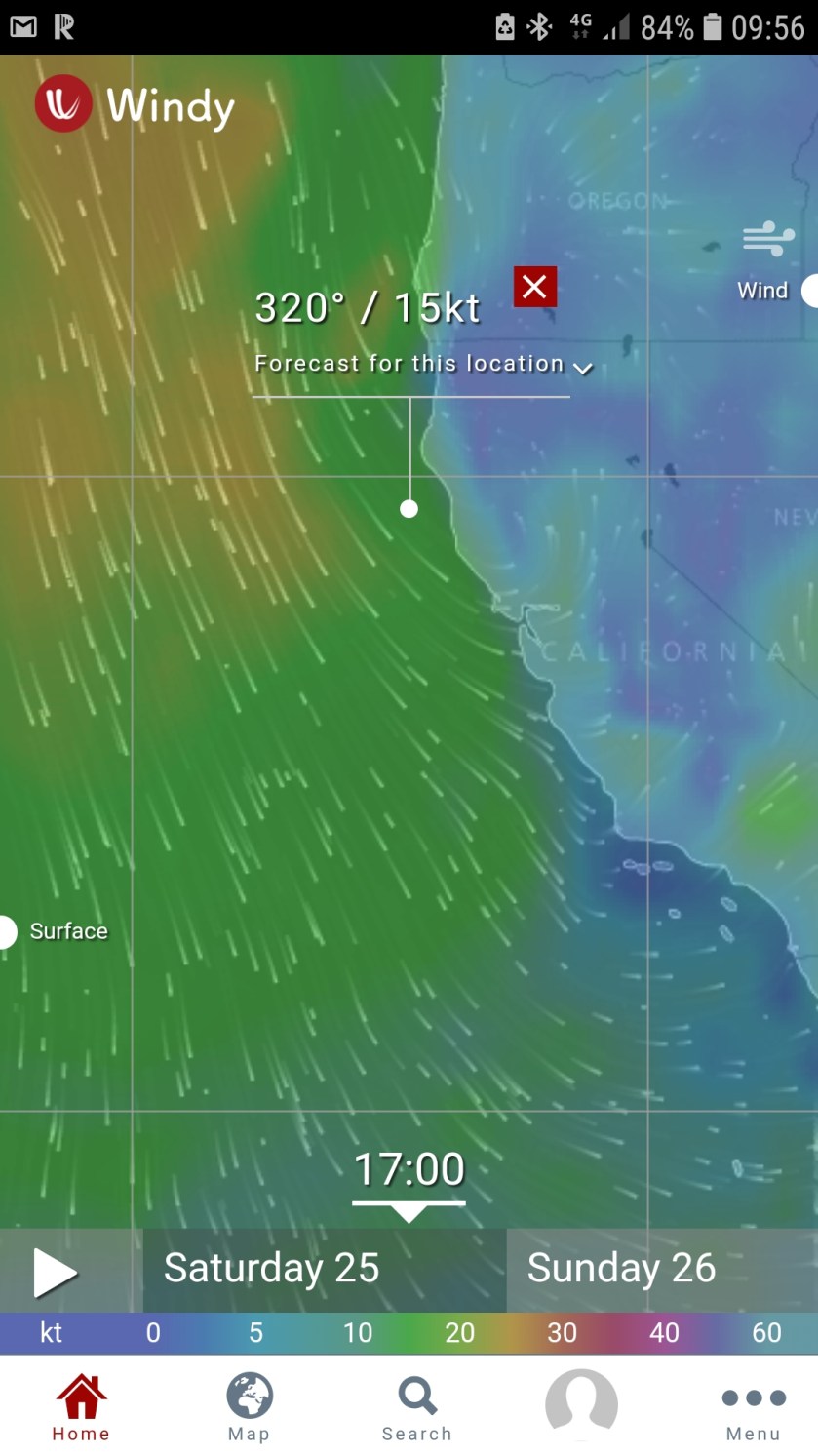
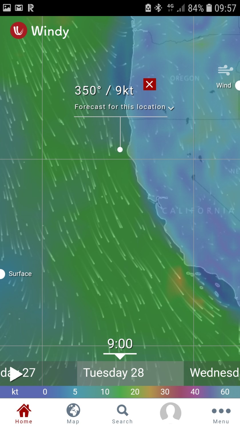
The fist picture on the left shows my main area of interest at the white dot, just south of Cape Mendocino. This is where the winds are the strongest. It’s a two day (46 hr) cruise to Crescent City, just north of that spot.
The sequnece from the 25th to the 28th seems to show improving condidions along the sure, with the strong Northerly winds moving off shore.
It could well happen. But what I focus on is the large overall pattern.
So while it is showing a small area of light winds along the coast, that if it came to pass as depicted, it would be ok, even good to leave San Francisco and head north, the problem is the area of favorable winds is very small.
I’ve always said that forecasts are more often correct, but id they are wrong, it’s usually an issue of location or time, but not the event. For example, a cold front with showers and thunderstorms is forecast to move thru your area in 12 houris time. In reality, it could be 10 hours, or 8 hours, even 6.but it’s happened.
Where it happened is another story, That’s what I mean my location. Forecasting snow anywhere along the east coast is always problematic. A lot of things ahve to fall in place for the forecast to be spot on at a given location or time. The snow-rain line could end up being 10 miles west of New York City. After the news media has panicked everyone for days, it looks\ like a big bust, but in reality, looking at the large scale picture, 90% of the areas that were forecast to get snow got it, same for rain, it was only that little band that was incorrect.
And that’s what I’m thinking of as I look at these three days of forecasts. The overall pattern really doesn’t change much. This little narrow area of light winds could easily end up being 20 miles to the east leaving me frighting winds and waves.
Most importantly, all the pictures I have posted here are the only things I have looked at to make this decision. This gives me an overview. Until the overview looks more than doable, there is not point in in spending time looking elsewhere, at other products or other models.
Om addition, if you find yourself trying to find the right model to five you the forecast you want, you are only cruising for a bruising.
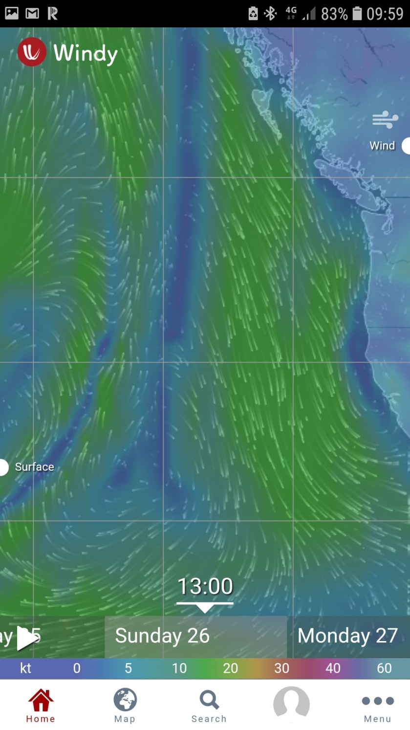
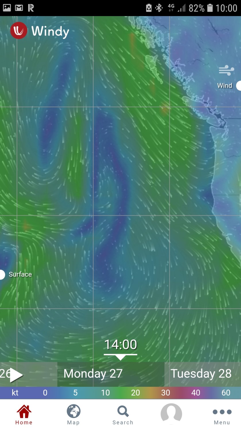
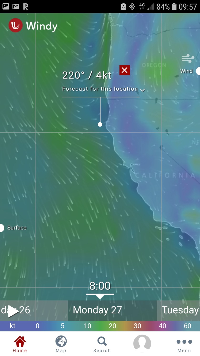
Two days ago, here are the Windycom woeather maps I looked at to tmake my decision if 23 could leave on the 25th:
24th 1500 Overview25th 1300 OV25th Cape Mendocino26th 0800 CM w narrow High. It looks good, but it’s a sucker hole.26th 1300 overview27th 1400 OV27th 0800 CM28th 0900 Cape Mendocino28th 1200 OV29th 1200 OV
It’s 7 days to Washington’s Neah Bay. The first few are the most critical, since off the Oregon coast, the winds are more from the southwest in general. So, the California portion is the most difficult.
I’ll wait until the entire high pressure system moves east. I’d rather have 30 knots from the SW than 10 knots from the north.
As spring gets closer and closer, I’m watching the weather daily. I know what I want, but the light wind conditions may only last a couple of days, while I need a week plus.
In the last weeks, the more I have thought of this, the more I am thinking of getting north as best I can, probably well offshore.
Offshore solves a number of issues for me:
I like the open ocean
far less fishing activities, like boats and nets
more sea room, if I need to run before the storm (this is always a consideation in my planning)
getting big chunks of distance done in a short time, 3 days = 500 nm
did I say I like the ocean
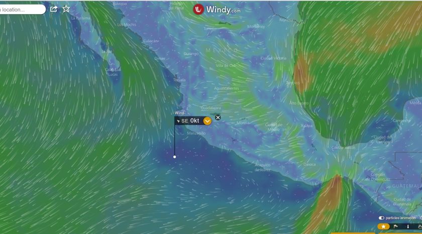
I like the GUI and data presentation of Windyty.com, so all the maps I show are from them and when I do look at weather, I look at them before anything else. This is what a great case looks like. How long it will last? Not long enough, but a few days, then with a low pressure system developing further west, would give me favorable winds for the second of two 3-day periods (the steaming distance between Huatulco and Cabo San Lucas is 900 nm or 6 days.
Now this looks great. Too bad it will last a day or two and I need 9!
This case though is far more typical, with NW winds >15 knots, even more so in the summer than now.
As I sit in my 10th floor apartment in Ho Chi Minh City, a.k.a. Saigon, the People’s Republic of Vietnam this balmy January 2018, writing these words, I think back one year. I was in Martinique, in the Lessor Antilles, luxuriating in having just completed a harder than expected crossing of the Atlantic from North Africa to North America.
Looking north from my apartment in HCMC, Vietnam
Vietnam wasn’t even on the radar and if it was, I thought it was a wave top. Impossible it imagines how different 2017 would end up.
So, how can a person who doesn’t have a clue as to where they will be in 12 months’ time write about planning?
And not only write about, but spend a good portion of every day’s waking hours thinking about The Plan? So much so that just a while ago, I found myself looking at the noonsite.com information about Taiwan.
Taiwan? wtf, he still hasn’t figured out how to get Dauntless out of Mexico, you’re thinking.
And right you are. So, I thought you would be interested in knowing or better understanding my planning process.
To understand my planning process, let’s look at my goal and some background information:
The Goal
Long term, cross the North Pacific, return to Northern Europe & complete my circumnavigation.
Short term, spend a couple of summers in Southeast Alaska.
Near term, get Dauntless to California before next winter.
Dauntless is now in the wonderful little town of Huatulco, Mexico, in the little Bahia Chahue.
Background information
In 2016, once I made the decision to return to North America, I made an elaborate plan (published in some blog post last year) to transit the Panama Canal and cruise up the west coast of North America to SE Alaska.
Looking aback at the plan now, I stayed pretty much on time and on target, only transiting the Panama Canal a couple weeks later than originally planned, until Costa Rica.
Arriving in Golfito, Costa Rica in March 2017, the wheels then came off or a more apt description, I was beached.
What happened? A perfect storm of: local bureaucracy, my nephew who cruised with me since Ireland, had to go back to school and I met this wonderful woman in faraway Vietnam.
Returning to Dauntless in June, I needed to get moving north. Costa Rica is a wonderful country that I had visited in 2004 and had really looked forward to returning. But, it turns out, it is not really cruiser friendly. The few marinas are ridiculously expensive and the paperwork of checking in and out was cumbersome and confusing.
My newfound friend, Cliff joined me and we took Dauntless from Costa Rica to Mexico. Mexico, it turns out is everything Coast Rica isn’t. Cliff had to go back to work and hurricane season had arrived, so in reaching the wonderful town of Huatulco in August, I decided that enough was enough.
The Task at Hand is to get Dauntless from southern Mexico to California, 1800 miles.
Dauntless cruises at about 6.5 to 6.8 knots. thus a 24-hr. period is 150 nm. That’s the figure I use for planning. With light winds and small seas, then the planning exercise is about planning stops after a day of cruising.
Two years ago, in the Baltic Cruise, I largely ignored the weather and planned the whole 4,000-mile trip based on cruising days of 5 to 8 hours. Usually we would stay a few days in each town or city stop. But the pacific coast of North America is a whole different creature.
Climatology tells me that the winds are predominantly from the northwest (the direct I must go) 2/3’s to ¾’s of the time. I use Jimmy Cornell’s Ocean Atlas which has pilot charts for each ocean by month. Jimmy Cornell’s Pilot Charts also tell me the secondary wind direction and currents. June thru September is 4 months, 120 days. I figure that I will have favorable winds about ¼ of those days, or 30 days. I have 1800 nm to go divided by 30 days means 60 miles per day. No bad, about what I did in the Baltic in September.
But it also means that when the winds are favorable, I must make miles. The reality of seasonal climatology is best looked at and planned for over periods longer than a few weeks. In this situation, I can easily be stuck in port 30 days waiting for the winds. Then if I’m lucky, I’ll have a good period, 5 to 10 days of southerly winds. Depending upon where we are along the coast, it means we may do 48, 72 or even 96 hours to take advantage of our good weather window.
Now in this context, when I say “weather” I really mean winds and seas. I’ve left port on many stormy days. Rain, showers do not bother me, it’s really all about the winds and seas for my little Kadey Krogen.
The effect of head winds and seas vary greatly. 5 to 7 knots are hardly noticeable and may produce small seas, less than 2 feet. Dauntless will lose a few tenths of a knot under such conditions.
Going out into the storm
As winds off the bow become stronger, it all goes down rapidly from there. 12 to 15 knots produce 3 to 5 ft. seas, pitching become unpleasant and we’ll lose more than a knot of speed. 18 + knots are untenable from a comfort level. Too much hobby horsing and probably down to 5 knots, less with any counter current. This is what happened to me off the French coast going up the English Channel to Holland. We were making 2 to 3 knots in pure misery of pitching. Because of the conditions, I finally decided to abort to Ostend, Belgium. It took another 6 hours to go 15 miles. Some of the worst 6 hours I have ever experienced. The Kadey Krogen was fine, she takes a beating and keeps on ticking. The humans inside were not as happy.
What I took out of that beating was to more carefully consider winds and seas on the bow. A 20-knot wind from the stern is fine. We had 20 days of that crossing the Atlantic last year. Even 20 knots (and resultant seas) on the beam are ok. The paravanes are most effective with beam seas. Though I tend not to venture out in such seas if I am in port. 20 knot headwinds are untenable. Stay in port. If at sea, options are reduced, but probably a change in direction is warranted.
I use Windyty.com for my forecast winds. I tend not to look at forecast seas because the accuracy is seldom good enough to use in an effective manner. Though Windyty will give you the first, second and third swells.
Now when it comes to forecast winds, for whatever reason, the forecast winds are almost always understated, though I do realize it’s possible that I only notice the over and not the under. Thus, when winds are forecast to be 12 knots, that usually means 8 to 15 knots. If 8, ok, if 15 it’s a no go. So, in this case, I will use 8 knots for the Go-No Go decision.
From Huatulco to the Channel Islands, it’s only 1800 nm in three long legs. that’s basically the distance I did between Martinique and the Panama Canal. But with much more un-favorable winds and currents.
Top speed for Dauntless is about 8.5 knots, but it’s non-factor because it’s impossible to justify the double to treble fuel consumption for 2 knots. So, my effective (long term) hurry up speed is 7.5 knots at 1800 rpms and 2 gallons/hour. Thus, I usually keep it to 1700 rpms, 6.8 to 7.0 knots and 1.6 gal/hr.
In my next post, Planning is the Mother of Anticipation, I’ll discuss the Mexican coast, what options we’ll have, crew and hurricanes.
Should I have stayed in northern Europe for another year?
The route I ended up taking between Galicia in the Northwest corner of Spain and the Canaries.
First the additional year. I love Ireland, the people, even the weather (you never got bored). But Ireland itself is not really cruising country. Getting up and down the coasts can be a bitch, at best. I did love A Coruna though. Why not there? That was Plan B after all.
Then Schengen reared its ugly head. For those of you who still don’t know what “Schengen” is, it was the city in Luxembourg in which almost all the countries of Europe (nothing to do with E.U.) decided to have open borders in 1989. Open borders meant just that. Prior to 1991 or whenever it went into effect, one had to stop at each and every frontier and show passport. On my many drives from the Netherlands to Italy, that meant 3 border crossings. But they were pretty quick (nothing like the USA-Canada boondoggle). They never even stamped your passport. While the rule was, you were allowed in 90 days in each country, no one cared and as I said, no one stamped passports other than at airports and not even then many times.
But with Schengen and the open borders, they decided they still had to control immigration. Therefore non E.U. people could only stay 90 days out of every 180 days. So, before you could move from country to country every 90 days a stay within the rules, now, you had to leave the continent or go to the U.K. or Ireland. That’s why Dauntless was in Waterford.
Ultimately, I realized that to keep Dauntless in A Coruna for the winter would not be feasible, since I could no longer go to NYC for 3 months and then return.
By the way. So, Schengen was written to keep people from overstaying, yet today the E.U. gets about 200,000 people a month from Africa and the Middle East.
But they got Dauntless out so all is OOOKKK.
And another aside. While those morons in Washington debate who to let in. NO ONE, Dems or Republicans, talks about we have no system to track who leaves. Wouldn’t you think if we really cared, the first thing would be using one of the billion computers the government has to track people as they leave and compare that list to who came in. What a clown show!
Now, sorry for the diatribe. My route which took me down the coast of Portugal and around the corner to Gibraltar. I didn’t even see the Gibraltar Apes.
I suppose the real issue here is that we were really beaten up almost the entire trip from Porto, Portugal all the way to the Canaries. By stopping in Gibraltar, I added about another 360 miles to our trip.
I actually had a sailor in France tell me that I should go direct to the Canaries from Vigo in NW Spain. But I wanted to see Portugal and I am glad I did.
The route I should have taken
But southern Spain and Morocco, ended up being exactly what I expected, hot, dry and dry and hot.
I could have spent those weeks in the Canaries. The Canaries reminded me of everything I liked about Galicia. Great people, food and a boating culture.