20180513 Three Times Fail – Cabo Falso Beats Dauntless Like a Rented Mule
Coastal Explorer chart with Maretron data overlaid
Cabo San Lucas was the most un-Mexican, unpleasant place I’ve been in the beginning of time or at least since I’ve been cruising Dauntless for the last 7 years.
It was expensive, literally, 3x to 10x more expensive than anyplace else I’d been in Mexico. The epitome of a tourist trap; I thought I was in Southern California.
Unexpectedly, Ensenada, being much closer to California, was truly charming. I could have been stuck there for months and been happy, conversely, being stuck in Cabo waiting for weather for 10 days felt like a year!
So, this video shows me attempting to leave Cabo just days after my arrival. I was now alone again; Larry was going to meet in the next week and I was hoping to be in Ensenada by then. Once making the right turn to the west at the very bottom of the Baja California peninsula, one heads due west to get around Cabo Falso, before turning northwest and then north to get up the coast. The winds are typically strong and right on the nose 15 to 35 knots. 15 is not pleasant, but is tolerable, high teems quickly becomes untenable for any length of time. Even under the best conditions, I would have a few hours of the strongest winds.
Sorry I don’t have more video of the worst moments, but when I’m being thrown around the pilot house, my last thoughts are on making videos.
Please remember to Like & Subscribe to my YOU TUBE videos, it makes YT like me better.
Dauntless returned to the USA on June 9, 2018; four years after she left Cape Cod, Mass. I left with Julie and came back with Larry, an interesting swap. But it’s nice to share special moments with special people and I’ve known Larry since we met on T-3 in 1973.
Error
This video doesn’t exist
CE chart of our arrival in San Diego
He’s good crew. He knows how to find the best ride for the conditions of wind and seas and he knows when to call me.
The check-in pier to the USA in San Diego is at the police dock at the entrance to the harbor. When we arrived at 19:00 there was a large fishing trawler occupying most of the dock. A spot on the Visitor’s Pier was open and I took it. Upon calling customs and Immigration, they told me everyone was busy with that fishing trawler, took my number and said they’d get back to me.
Noon , 6 hours from SD
Some minutes later, they did just that. Telling me they were busy, they asked if we had Global Entry. We did, they took our passport numbers and welcomed us to the USA. After the nightmare of paperwork that the Caribbean is, I welcomed some common sense.
Larry and I celebrated our return by going to the typical restaurant & bar ubiquitous in the USA at upscale marinas and sea shores. We paid a lot for the crappiest meal we’d had in weeks. Welcome Home.
The Visitors Dock
It was 17 days from Cabo San Lucas to San Diego. I’ve written about most of the highlights or lowlights already. If you missed it, here are some links:
The last 17 days saw us biding our time in anchorages, opposite, hot, dry, almost deserted towns, waiting for strong NW winds to subside so we could proceed NW in weaker NW winds.
Everything ended up working out so well thanks to generous friends and wonderful strangers.
Yet, I feel a disquiet that I hope is nothing more than the phase of the moon.
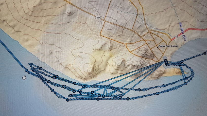
After arriving on the southern tip of Baja California May 9th, two weeks later we are faintly getting out of this tourist trap. Oh, Cabo, or better yet, Cabo Falso, has finally loosened her grip on us to to us pass.
My two previous attempts were unpleasant at best, more like miserable. And on each the previous attempts to round the cape in ferocious seas and winds, I had tried two or three times, either tacking away from shore or closer to shore to escape her grip. Each time, I dragged myself back to Cabo, tail between my legs.
On the second attempt, the autopilot also started to not act right, so I felt the failure even more.
My Octopus pump. the top screw was leakingThe screw, replacement “O” ring and broken circ clip for the Octopus pump
With thousands of boats in Cabo San Lucas, I thought it would be easy to find the little “O” ring and broken circ clip my Octopus pump needed. After walking around to numerous places in the hot sun, I found the ring, but not the clip. I called my followers who is a plethora of mechanical advice (he’s the one who told me how to make emergency hydraulic fluid in the middle of the Atlantic), who explained that the circ clip was just a stop, so the screw would not come all the way out. It was already out, so that solved that problem. I put the new “O” ring on, leak stopped, and pump worked fine.
The Garmin InReach track for the May 13, 20 and 23. The superfluous tracks are Garmin’s way of introducing us to their world. https://share.delorme.com/dauntless
I am really in debt to Octopus Pumps. This is on the list of winter projects. I really need to have a spare.
We waited and waited. I was very conscious that every day was costing me $100+ The reality is on my budget with all the cruising I do, necessities come first, so a marina becomes a convenience. Thus, it’s the one place I really try to try to control my costs.
That I didn’t like Cabo just added insult to injury.
I make a habit to only look at Windy.com and the forecast winds once or twice a day. With crew on board, I look at it more often to make them happy, but I really don’t. The nature of forecasts is that if they change radically, they are most probably wrong. Thus, once a day will provide enough guidance. Also, while nowadays, the forecast models are run more often, at least every three hours, planet Earth still has a 24-hour day. In simplistic terms, the winds and weather are driven my differential heating caused by our day and night cycle. Therefore, running the model more often does helps, but it won’t totally cure instability issues with the forecast.
I know this is getting too complicated. Let me say this, if you are waiting for a specific weather window, like I was in Cabo, how many times have you noticed that during the day, the forecast is changing, only to return to what it said originally 24 hours later? So, looking at a forecast more than a couple times per day is simply not helpful and more often confusing. This was quite apparent as I watched the winds off the southern Baja Peninsula.
The other phenomena with numerical forecasts are the sliding weather window. I mean it shows favorable whatever in the 24 to 48-hour time frame. But the following day, the favorable whatever is still forecast to come in the 24 to 48-hour time frame. It’s like the forecast is waiting for something to happen. It is in fact; numerical models are just predictors of fluid dynamics. But something in the real world is not acting like the model suggests. Therefore, it keeps sliding the forecast.
Which is fundamentally why numerical models have not replaced weather forecasters. Weather forecasters will know the proclivity of each model for each area and time of season. Changing seasons is the biggest bugaboo for both man and machine. That’s why some months are easier or harder to forecast.
Enough weather for now.
Rounding Cabo Falso
Error
This video doesn’t exist
On 23 May 2018, we finally got underway heading to Ensenada with stops along the way. The first protected stop was Maddalena Bay, about 200 miles up the coast.
Our track on Coastal Explorer. We are finally past the point that we turned around last time.
Coming abreast of Cabo Falso, winds had picked up to 310° at 15 gusting to 25 knots. I put one bird in the water to reduce the roll, which had gotten to 10° to 15° to port, as the winds were on the forward starboard quarter. We were pitching 6° to 8° up and down. Not fun, but tolerable for a while.
Six hours after departure, we were finally around the cape and heading NNW. Winds had died down to 10 knots, but we still had an unpleasant pitching motion.
Night view of Coastal Explorer our first night out of Cabo. You can see the pitching and rolling motions for the last 12 hours on left on bottom of screen.
During the spring and more recently in my time in Cabo, it was apparent that there are three distinct weather regimes off the Baja coast. The southern third has the strongest and most consistent NW winds. The second third has slightly more variety, while the last third, north of Tortuga Bay, must more variable weather, more like southern California.
Our Coastal Explorer chart showing our route for the previous 36 hours, after arrival in Magdalena BayNavionics on Tablet, further out view on Coastal Explorer, as we proceed up the channel in Magdalena BayAnother view out the pilot house window, with Maretron and Coastal Explorer chart
Not until we were close to Magdalena bay did the winds back around to the west, though they were strong at 15 to 20 knots.
We pulled into Magdalena Bay 17:00 on the second day, the 24th, we then spent a few hours going up channel to Puerto San Carlos, to be protected from the coming wind storm.
Another view out the pilot house window, with Maretron and Coastal Explorer chart. It did stay like that the entire time