The Rest of the Story

Larry had returned to Alaska also, so when I got back to Dauntless on the 24th. I’d be taking her the last 400 miles of this 2000+ mile trip to Vallejo on my own. I had a plane ticket to leave Sacramento on 3 July to Austin.

My route thru Channel Isl Harbor

Assuming I had to arrive on the 2nd, I had 8 days to get to Vallejo. Ray, one of my boat mates in the new marina had kindly offered to give me a ride to the airport at 0h dark-30, so, I was back on the clock.

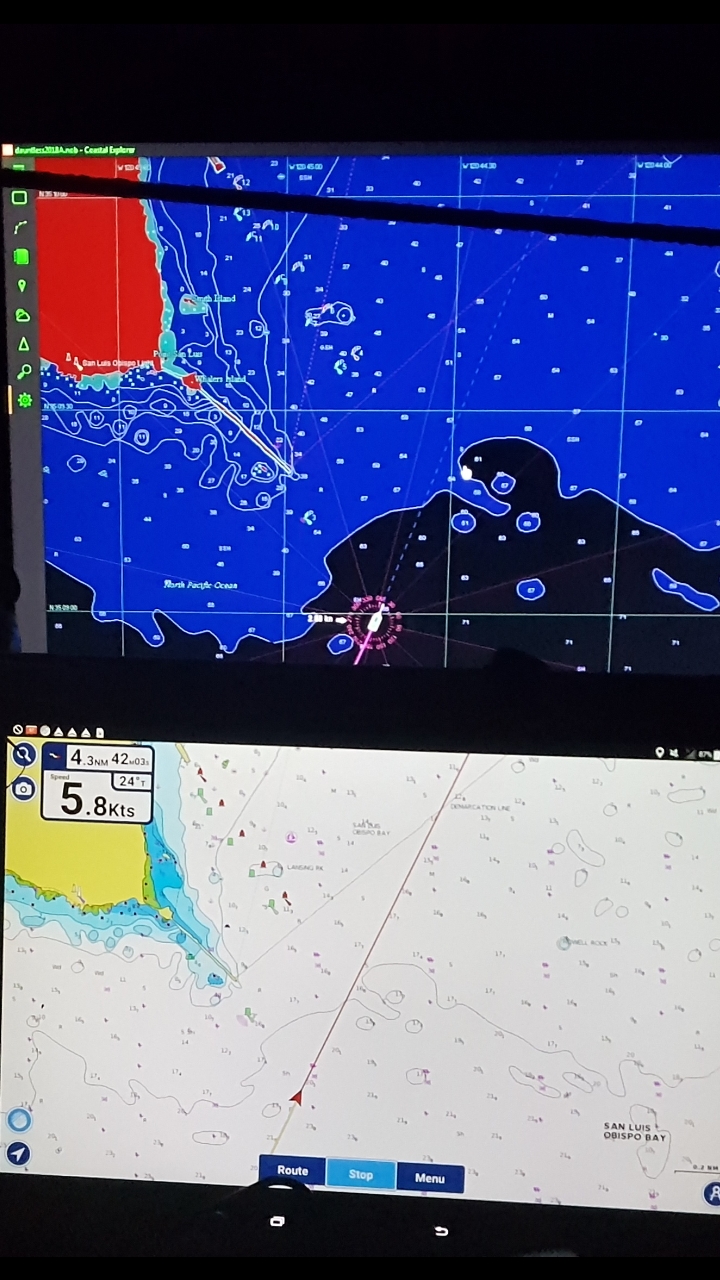
The first leg was critical, 70 nm to Point Conception. Winds had been light or southerly for two days, while I was in Salt Lake City, now, my day of departure, Monday they were forecast to increase from the west as the day progressed. (This is the way I use weather forecasts, looking at the trend, but not necessarily believing the specifics). 70 miles is 12 hours steaming time. I wanted to get around Point Conception before 16:00, otherwise as winds picked up on the bow, we would go slower and slower and I would become ever more miserable, yet again.

Therefore, I planned my departure from Kyoko’s dock at 04:00.

I never sleep well before embarking on any kind of trip, be it, by plane, train, automobile or boat. Thus, I was up just after 3 and figured I may as well get this show on the road.

I have a standard departure procedure. One that I adhere to since pulling away from the dock in the Chesapeake, 4 years ago, only to have the engine stop two minutes later from no fuel. At that time, I dropped the anchor in emergency mode (pulling the chain out of the wildcat and letting the anchor freefall) to stop our drift into nearby boats. Once that was done, I headed to the engine room to see what happened. A quick glance showed both fuel tank feeds were closed. Since I had just opened one, it was clear to me that in my mindset to “open” a closed valve, I had closed the one that was open. So much for check lists.

Getting Underway at 04:07

Way back then, I still did not have my auxiliary fuel pump installed, so of course it took 10 minutes of lift pump masturbation to get the air out and everyone happy again.

Consequently, I follow a standard start up routine, which consists of:

  • Engine room check, smelling and looking for obvious leaks and confirming fuel feed and Racor use.
  • Engine start
  • Turn on breakers for:
    • Running lights
    • VHF radio
    • Radar
    • Auto Pilot
    • “Loran” that’s the breaker used for my USB ports now
    • Horn
    • Check Anchor light is off
  • The boat computer, modems, router, Maretron system, two Samsung LCD displays are all 12 volt and on a separate breaker that is not on the pilot house system. They were already on, as that system takes a few minutes to boot up, as the router can be picky.

Now, on this night, I had already taken one spring line off before I went to sleep. In hindsight, that was probably a mistake, as it got me out of my routine.

Channel Isl Hbr overhead docking

03:30 I did my engine room check. I was also out of my routine because my engine room bilge pump was off and had been for the 10 days I was on this dock. With the little leak I had from the transmission, while no significant oil would be discharged, it would still make an embarrassing oil sheen, would not be nice for Kyoko and Mike, who had so graciously given me this spot. I could easily wait until we were off-shore.

03:43 Engine start. To this day, it is unclear to me what I was thinking. But I didn’t turn on the Auto Pilot or the Radar. More likely I did, but in any case, I untied from the dock, without realizing that neither was on.

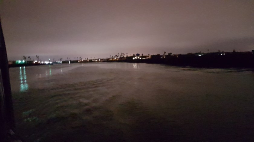
03:52 Free from the dock and underway. I make the 90° turn to starboard to clear the dock, at which point I realize the Radar is not on. It’s dark. I don’t travel without the radar in the daytime, let alone now. But what to do.

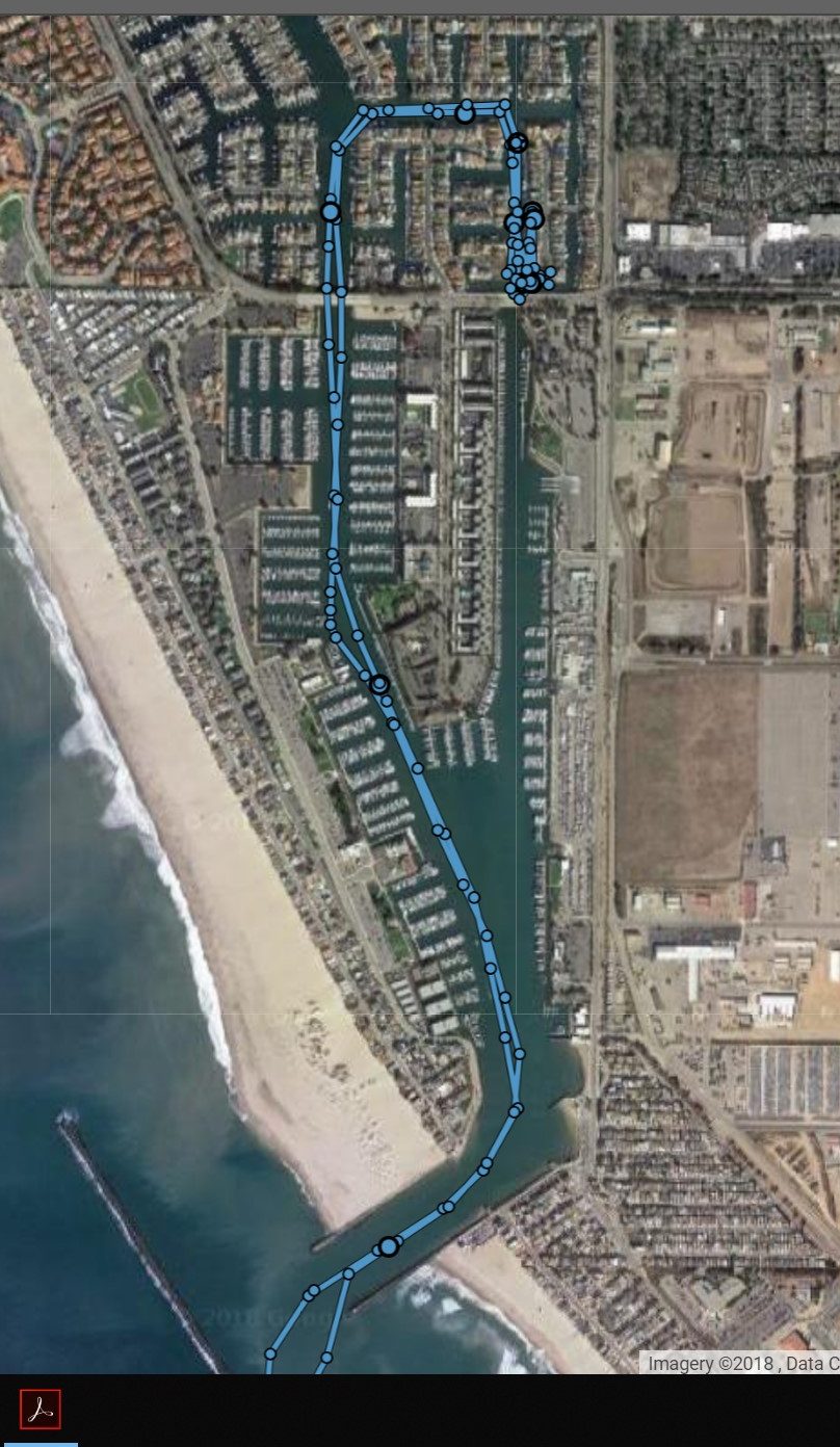
These fairways were relatively wide, maybe 150 feet, but with boats and/or docks on either side. To return to Kyoko’s dock, I would have to do a 180° to port, then a 270° to dock bow facing out, as I was. In the dark, alone, that did not appeal to me. I also did not want to dock bow in, tie on the port side, as all my lines were on the stbd side. Again, being alone, limited my options. I decided to press on and look for a convenient place to stop to be bel to diagnose and solve the electrical issue.

In hindsight, I should have turned around and docked bow in. As it turned out, where I did decide to dock had a current that was vexing. At least this was a dock I knew. But at the time, I was more concerned about hitting something and felt it would be better someplace else. There must be some fuel dock or some such on the 40 minute it would take to go thru the channels and harbor to the sea.

My abrupt stop of video and boat for that matter is because while approaching the bridge, I was sure it was the same bridge I had come under two weeks earlier. But then, it that moment of panic, I thought maybe in the dark, I had made a wrong turn. I didn’t, but that’s what being in the dark will do for you. 

Error
This video doesn’t exist

So, I slowed to inch under the bridge. I then proceeded to spend 15 minutes trying to back in a dock. With no current, it would have been easy, but in this case, there was a current, pushing the boat and especially the bow to port, so as I backed I’d end up almost perpendicular to the dock. After 3 or 4 attempts, I gave up and decided it would be easier to just go bow in around the corner. It was, and I did.

Coastal Explorer and Maretron data laving CI hbr

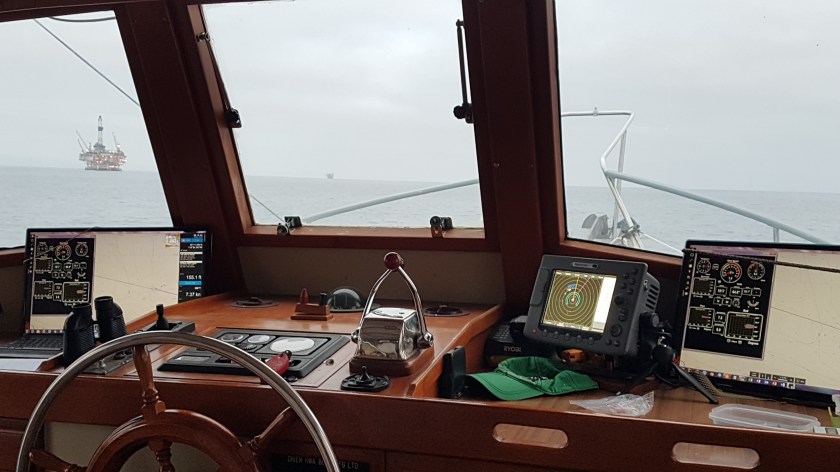
Just tied to midships. The boat secure, I was able to get under the helm to see why I had no power to the radar and autopilot.

Pilot house voltage has been an issue since day 1. I need to run a bigger or additional line and ground to the pilot house. When on long cruises, once the batteries are fully charged, the voltage at the batteries goes to 12.85v or thereabouts. The problem is that voltage in the pilot house is down to the low 12v. The Raymarine radar display will blink out momentarily when the voltage dips below 12. This usually happens when the auto pilot commands a longer turn. It gets annoying. So, since I never got around to running the additional wires, I instead did my normal half-assed fix of jumping from one buss to the other. The pilot house electrical panel has three separate busses. It used to be two, but sometime a couple years ago, I thought I had a fix for the radar by making a third buss. It sort of worked.

But coming north with Larry the radar display (not the transmitter or computer, only the display) started blinking again. I added another jumper. Worked great. But then upon arrival, I redid in a different way. Why? who knows!!

That different way is what was not working. I realized right away why the autopilot wasn’t getting power. So, I put it back the way it was, and all was good. That took 5 minutes. The additional docking took 45 minutes.

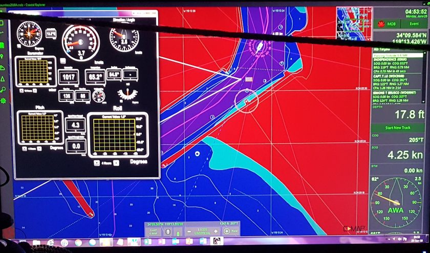
That delay would bite me in the ass later that afternoon.  Once I got out to sea, the winds were light from the south or southwest. I was headed 280°, just north of west. Winds out of the south were good, east better. Late in the morning the winds started to turn to 280° at 06 kts, right on the nose. 3 hours later at 14:00 they were 28012 g 15 kts, pitching had increased to 12° up and down and speed was reduced by one knot.

Underway again
Error
This video doesn’t exist

I was able to make the turn to the NNW, 340° at 16:00. Winds had already increased to 290° 14 g 20. The turn took the winds and seas off the bow to the port forward quarter, much better than dead ahead. I was grateful for my early morning start.

The rest of the day was a piece of cake. Winds stayed 300° 15 g 20 for the rest of the evening. We were pitching and rolling, but it was tolerable. I didn’t jump overboard as I have been tempted to do when going into ahead sea.

And now you know the rest of the story.

Passing an Oil Platform south of Santa Barbara

I arrived in off Avila Beach in San Luis Obispo Bay around 22:00 and anchored that night using the radar. But then you already knew that.

Anchoring at Night


Advertisement

Anchoring at Night in Strange Places; It’s not for the Faint Hearted.

Only day’s away from completing this 2,000-mile, two-month journey, I found myself breaking yet another of my hard and fast rules I made for myself 5 years ago.  Entering yet another harbor at night, and having to anchor by radar, avoiding darkened, moored boats and mooring balls.

But like most hard and fast rules, I had to weigh the circumstances against various risks. In this case, anchoring at night was the least risky option. I’d left Channel Island Harbor at 04:00 for the 120 nm voyage to San Luis Obispo harbor. I’d planned on 19 hours. Thus, to arrive before sunset, would require me to leave the Channel Islands at midnight.

Leaving anyplace at midnight means a total disruption of my sleep cycle. I’d be starting a long trip tired and already behind my personal power curve. By leaving at 04:00, I’d be able to get a reasonable 6 hours sleep and 03:00 is on my natural wake up curve (though normally, I’d go back to sleep for another 3 hours).

Raymarine E-80 Radar, C-Map on Coastal Explorer, Navionics chart on Samsung Tablet


Therefore, anchoring in a strange harbor at night seemed for me to be the lessor of two evils.

Let’s talk some basics. Four years ago, I hated my Raymarine E-80 Radar. I felt (and still do) that it was 1980’s technology, dressed to look like the 21st century. It was on my lest to replace at the earliest opportunity when money allowed. I had wanted a radar that I could integrate into my Coastal Explorer and C-Map chart plotter, navigation program.

San Luis Obispo harbor

Using the “Auto” settings, the E-80 will show you if the Exxon Valdez is bearing down on you, but otherwise, it either filters too much or not enough to be useful for close in maneuvering. As the miles and time increased under my belt, I learned how to best fine tune the radar using the manual settings for gain and sea state (which is basically a filter) to make it an effective tool.

Whenever I start the engine, I also turn on the: radar, navigation lights, auto pilot, VHF radios and horn.

Always.

For the first lesson in using the radar is that you must use it when the visibility is ideal, to be able to effectively and safely use it when the visibility is impaired, whether due to darkness or weather conditions (mainly fog, rain is another issue).

While underway I’m constantly checking and identifying any radar contacts visually, as well as on the navigation charts (for navigation markers, buoys, etc.).

As soon as I spot something the radar does not see, I adjust the radar, fine tuning so to speak. Normally this is just a matter of adjusting the sea state setting, though sometimes I also must fine tune the gain. E.g. I may see a fishing skiff a half mile off my starboard quarter, but it’s not showing up on the radar. I’ll have to lower the sea state setting, maybe only a few points, until the skiff shows up, but not the countless wave tops around it.  Sometimes, I’ll have to adjust the gain also.

My goal is always for the radar to show me potential hazards, without showing me wave tops. For the last couple of years, my tuning technique has been good enough to do exactly that. Forget the “auto” settings, they are hopeless.

Since I don’t get many false alarms, this also allows me to maximize the use of the two zone monitors.  For coastal cruising, like I’ve done since entering the Pacific Ocean, I set up a ring at ½ mile, that’s an 1/8 of a mile thick. Thus, if anything enters that ring you get an alarm. If you just put a circle around your boat at ½ mile, the radar will see some clutter very close to the boat and thus render the alarm, ineffective at best and annoying at worse. I make this ring go about 220° to 300° around the boat. That way it will see something approaching from the stern quarters, but not directly behind, as the radar will occasionally see a reflection of the mast, again making it ineffectual.

The second zone I set up 1 to 1.5 miles from the boat, in a much more 20° arc.

On the open ocean, well away from land, I’ll basically double these distances.

If I do get any false alarms, I adjust again. Usually it happens as the sea state gets worse (bigger seas).

For my set up, I find values of both the gain and the sea state in the 70’s to work best. In flat seas, I can lower the sea state to just above 50, but again, even changes of 1 or 2 can make a significant difference.

On this night, entering San Luis Obispo (SLO), as the seas calmed as I entered the bay that is protected from the NW through the East, I readjusted the sea state, lowering the filter values. From my charts I knew there was a mooring field, presumably with some moored boats. I adjusted the E-80 so that it would pick up objects as small as the mooring balls. Had the seas been above 2 to 3 feet, this would have been an impossibility, but if I had such seas in the harbor, I wouldn’t be stopping in any case.

This night, with strong NW winds, the harbor was well sheltered and the seas where maybe half a foot or less. Under those conditions the radar will do well.

I open and secure both pilot house doors, so that I can have quick access to looking out. I also go to the bow to scan the approach with binoculars (7×35), which I find very effective a night in poor light conditions.

Thus, I have that visual picture in my head, while checking the radar to ensure it’s seeing the same things.  Again, because I am constantly doing this in the daytime in good visibility, I have the confidence to know what the radar is telling me at night, when I must trust

Here is a short video of  it of me getting ready to enter the harbor:

Error
This video doesn’t exist

Here are some stills made 2 minutes before the above video:

The radar 2 min before I took video
Coastal Explorer using C-Maps above, Navionics on tablet below

Three years ago, going through the main shipping channels of the Kattegat to the Skagerrak over the top of Denmark, I was terrified by what my brain perceived as the massive ship about to crush Dauntless. I was outside the channel, marked m red buoy, I knew the ship had to stay in the channel. The radar told me the buoy and this massive ship were ¼ mile distant, but my brain, every time I looked at the ship, I could swear was less than 50 feet away.

My mind was so convinced this ship was towering over us, that even as I checked and rechecked the positions of the markers on the chart and the ship and marker on the radar, all showed the target as more than a quarter mile away, but my mind would just not accept it.

I only calmed down when the ship was past.  In the daytime, my mind would not have been fooled, but at night, the perspective of distance, becomes very difficult.

I realized then that if I was going to continue to travel at night and not die of a heart attack, I had to make sure I knew exactly what the radar was telling and what it wasn’t and once done, accept what it showed.

So, this night, almost midnight, as I pulled into SLO bay, the radar guided me to a large area with a diameter of about half a mile with no mooring balls, though there were a couple of boats anchored on the west edge.

No fuss; no muss,

I was anchored in 25 feet of water at 23:20 having done 120 nm in 19 hours and 30 minutes, at an average speed of 6.2 knots.

The trip from CI Hbr to SLO. The Maretron data for pitching and rolling shows I did a fair amount after I rounded the corner to head north.

The morning after:

Error
This video doesn’t exist