Costa Rica Days 5 thru 7 – Isla Cedros & Jesusita to Bahia Guacamaya

I stayed two nights in the wonderful, quiet, still anchorage of Cedros & Jesusita.  It gave me time to catch up on my

Sunset in Bahia Guacamaya on 23 July

sleep and to complete the chores, cleaning and re-organization I should have done before I left the dock in Golfito.

Not the first time I have managed to stress myself by not finishing things as I should in a timely manner.

Won’t be the last, but still …

I hated leaving but it was time to move on.  I carefully followed by previous track out into open water.  If I didn’t take any shortcuts in; I certainly don’t take them on the way out.

I was underway before 8:00, as I had contrary current to contend with, I kept the rpms a little higher, 1700 today than the usual 1500 to 1600.  This gives me about an extra half knot, but also consumes an extra quarter gallon per hour or 17% more fuel.

Entering Bahia Samada at night of 22 July
Approaching Bahia Guacamaya


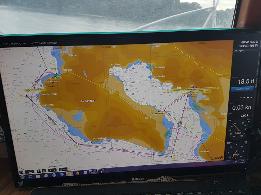
I was headed to Bahia Samada.  While it got good reviews on Active Captain, I’m starting to think all these reviews are written at a different time of year, with no south to west swell, because again it turned out to be rolly.

Also, buggy.  I’ve gotten in the habit like most experienced “cruisers” to turn on generator as the sun sets. It’s at this point that the winds will decrease or die and the bugs come out.  Also gives me an opportunity to put a little charge in the batteries, while running the A/C to cool and dehumidify the boat.

I usually run it a couple of hours, though I am conscious of the noise and it there are any other boats nearby, I turn it off sooner rather than later.

As I turned NE around the cape towards Samada, there was a large area of rain showers and thunderstorms, seemingly right over my intended destination. Though my timing worked out well in that the storms were moving slowly west, so while it rained for a while, by the time I got to the anchorage for the night, it at stopped.

As I said, not a great place to stop.  Rolly and buggy (mostly gnats).  Therefore, at the crack of dawn the next day, I was ready to get out of Dodge.

Hauled anchor at 06:00 and was underway to Bahia Guacamaya.  This place also got great reviews and for once it deserved them.  Hardly any roll, quiet, beautiful.

I stayed here two days.  I got the water maker running again, cleaned up the stern deck and jury rigged my garden hose reel that I use for the stern anchor line.  I did a good job, only wondering why I had not done it weeks earlier. Another unknown mystery of the universe.

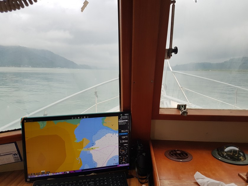
But even before that.  The trip was very nice.  When I had left the winds were light from the northeast, forecast to turn southwesterly during the day at about 8 to 10 knots.  As I rounded Cape Velas the winds were ESE at 20 knots gusting to 25.  That pretty much was the rest of the afternoon.  Very luckily, I was only a few miles off shore so the wind had very little fetch (the distance winds blow unencumbered over water) this kept the wave heights down, in fact they were less than 2 feet.

Dauntless was rolling on marginally.   Now had I come here a few hours later, the seas would have been much greater.  Just like the day I left Golfito, with the winds having blown all night, the seas were moderate by the time I left.

Also, I was able to check the latest forecast.  I use WIndyty.com for the most part as I love how they present the data and the options you have to change what you look at.  I pretty much only look at winds, though I may check the different weather forecast numerical models to see any significant differences. What was interesting about today was the forecast was very wrong, at least in terms of wind speed and for a small boat like Dauntless, that does make a significant difference.

I usually tell people, whether they ask or not, that weather forecasts are usually right, but when wrong they are usually wrong or time or location.  What do I mean?

The forecast was for 8 to 10 knot winds out of the east.  But 100 miles further north, the winds were forecast to be 20 knots.  So, in this case the forecast was wrong by location.  The timing was good.

Now since my Krogen on can go about 60 miles in 12 hours; 100 miles off on location makes all the difference in the world.  But if I was in an airplane covering a much larger distance, the location being off becomes much less of an issue.  Same thing if I’m a ship going 18 knots.

Now had I gotten up that morning with the winds blowing hard, I would not have left.  Because the other aspect of bad weather forecasts is that they usually don’t get better.  Meaning, if the forecast starts off incorrect, for any given time and place, it’s not like the weather will catch up.  Sure, it may look like the forecast is spot on 12 hours later, but more likely, it’s just a matter of chance.

So, I got to Bahia Guacamaya and just as advertised the bluffs to the east blacked the winds from getting into the bay.  Ver nice.  One of the best anchorages yet, certainly the best if I include the scenery.  So good in fact, I really regretted not have Trinh with me.  This would have been such a wonderful spot to explore together.

Here are some videos of the two days:

21 July 18:15, Entering Bahia Samada at night.  

Error
This video doesn’t exist

22 July Bahia Samada the following morning

Error
This video doesn’t exist

22 July 11:13 Underway to Bahia Guacamaya

Error
This video doesn’t exist

23 July Morning in Bahia Guacamaya

Error
This video doesn’t exist


Costa Rica Day 5 Summary: Engine Start 07:46, stop 18:50; uw 10 hrs 49 min, 67.7 nm, avg speed 6.3 kt. Average Roll while underway, +8° to -10°, delta of 18°;

Anchored Bahia Samada in 17 feet water with 100’ of chain out.

Costa Rica Day 6 & 7 Summary: Engine Start 06:00, stop 14:40; uw 8 hrs 30 min, 55.6 nm, avg speed 6.56 kt. Average Roll while underway, <5°either way, delta of 10°;

Anchored Bahia Guacamaya in 21 feet water with 80’ of chain out.


W’ere Finally on the Way to Mexico

After taking three days to Check-out of Costa Rica.

Sunset From Playa Coco, Costa Rica

And you think Vietnam is bureaucratic!

Stay Tuned

Track our progress at the link above that says, “Where is D Now?”


Oh, How I Miss My Navionics’s Charts

Costa Rica Day 3

Approaching C & J as the sun sets.
Don’t Do This at Home

As soon as my eyes opened due to the light thru my porthole.  I got up; it was time to get out of here. My night was not as restful as it should have been.  I was eager to get to the next stop which as I had read about on Active Captain, virtually guaranteed me an easy, peaceful, steady night.

I use Active Captain to search the best places for the current weather and sea conditions.  In North America, I find it indispensable.

I was so happy to get underway.  If you are going to be rolling around, you may as well do it while making miles.  I had a long day ahead of me, so I got going, before I made my Vietnamese coffee.

My Vietnamese coffee. The grounds go in the strainer on top of the cup.

Which will be another crisis looming in the distant horizon, the day I run out of Vietnamese coffee.  I really like it. I can make it very, very strong, almost like espresso, but it is not bitter.  At some point, I may think about importing it into the US.

But I digress.

It’s 06:30, I’m heading WNW to get around the cape’s further north and it’s a grey day.  With broken clouds, only a few patches of sky and rain showers from the previous evening’s thunderstorms lingering to the north and west.

I don’t mind the storms.  It all depends on the winds.  As

I approach C & J. Dropping the anchor now

long as the winds are favorable I’m happy.  On those days that I have choice as to leave or not depending on the weather, I pretty much only look at the winds. On a boat, the winds, speed and direction, are what makes a difference.  The boat is made to get wet, I don’t worry about rain.

Today the winds are light and while it’s a long day, it wasn’t bad at all.  As I arrive at my planned anchoring location, I am a bit perplexed because it doesn’t look like what I’d pictured from the charts.

Or I should say chart.  In one of the more bizarre aspects of my mind, I’ll make a plan and then when it comes time to execute, forget the main reason I made the plan in the first place. I can only chuckle.

In this case, for the last 4 years, I make it a rule to always have two electronic charts available.  The primary is on the boat’s computer and runs with Coastal Explorer, my navigation program.  I’m running C-Map (ex-Jeppesen) charts mainly because they are the most cost effective for world-wide coverage.

This is the Navionics Depiction that i DID NOT have available. Dumb ME. Notice it marks more rocks and the power line better

My secondary is Navionics running on my tablet. Also, extremely cost effective for tablets.

Except I left my tablet, who was dying from battery failure in Viet man, planning on getting a cheap tablet while in NYC.  But then I decided while in NYC to save a few pennies, since I’m only spending thousands of dollars a month on Dauntless.

I forgot about my Navionics charts.

Until now. At some point, I will do a review of the two charts, C-Map versus Navionics, but now, I just missed the other’s perspective.

Just then with the sun setting, a small open boat comes by and I decide to overcome my shyness and ask in my crappy Spanish for his recommendation for a good anchoring spot.

I do and he does.  I follow him about a quarter of a mile and he puts me on the spot.

In 26 feet of water I put out the anchor and snubber (I always use a snubber bridle, that takes the chain load off the bow pulpit and puts it to the bow hawse pipes and cleats).

This spot was ideal.  Even with the slight current, the boat felt like it was on land. It would slide around 90° every 6 hours, but the movement was not even noticeable.

I stayed here two nights.  In the 12 overnight hours, the boat moved 0.01 nm; the previous night, the boat moved (while on anchor) 1.7 nm!

I slept 10 hours straight and spent the next day doing more cleaning, organizing and minor stuff.


Day 3 Summary: Engine Start 06:20, stop 18:07; uw 11:39, 78.1 nm, avg speed 6.7 kt. Average Roll while underway, +7° to -9°, delta of 16°; extreme rolls delta 20° (not bad, half of what it was crossing the Atlantic)

Anchored off Isla Cedros & Jesusita in 26 feet water with 120’ of chain out.


A Long Day & Longer Night

Central America Cruise Summary Day 2

My Trip on the First Day

Tuesday, 18 July.  After waking up so many times I stopped counting, I was glad to see the dawn so I could get out of this spot.  Now I’ll tell you why:

I had gone to bed by 20:00 hours, having spent more than an hour futzing with anchors and snubbers.

Dauntless was as disheveled as ever.  I had to clear a line thru containers and chairs that had moved around the salon. The stern deck was a mess also.

Coming into my first anchorage

When I first put out the bow anchor, it was obvious the Krogen would not lie into the wind, but perpendicular to it.  Probably caused by currents in the bay, but it made the rolling even worse than it had been the previous 12 hours. But the next anchorage was 35 miles away, another 7 hours. I could not go on, I had to make this work.

First, I tried attaching the snubber like to the midships cleat instead of the bow as is normal. I also put out another 50 feet of chain after the snubber. My idea was to put some pressure on the side of the boat to try to hold it into the waves better. (This may have worked better had I connected it to the stern).

An hour later, I realized this was not working.  I started the engine briefly to get us into the waves, then threw out the stern anchor on short scope, hoping this would hold us in the right direction.

For about 15 minutes it seems to significantly reduce the roll.  I had made a pot of beans, corn and hot dog.

My dinner

That was my no so healthy dinner, but as I told Trinh, I hadn’t passed any gardens today. Besides humans can live a long time on a single food.  It wouldn’t kill me to not have balanced meal for a while.

I tried to go to sleep, but the boat had this terrible movement.  There was a rolling oscillation that would get worse after about 4 rolls, then die off for about 30 seconds before doing it again. No way could I get to sleep with that.  I got up numerous times to see if we had moved. We had moved but the bow anchor was doing fine.

I decided to move the snubber back to the bow. That helped the motion a bit.

Then an hour later, hearing a big bang, I jumped up to make sure we hadn’t crashed into the small fishing boats about 500 feet away. No, we hadn’t. But I then proceeded to pull in the stern anchor as I thought it must be contributing or causing the unnatural corkscrew rolling of the boat.

It seemed to work.  Now we were just held by the bow anchor.  Still rolling around and swinging on the arc from the anchor, I decided to brace myself in bed and just not worry.  I’ve possibly only dragged once with this anchor, so go to sleep.

That I did by about 01:00.  As the dawn broke a little after 5, I was up.  I decided not to deal with the mess in the salon until my next stop. But within minutes I found myself moving containers, chairs, getting the restraining straps and bungee cords and making everything snug.  A sweaty 20 minutes later, it was all done and I felt so much better.

Looking at the actual winds, they were easterly at 4 knots, so decided to press on and get out of this hell hole.  Clearly, I’ve been in worse anchorages, the ones you must leave sooner rather than later. But this one was pretty bad.

Got underway, 342° at 35 miles.  Should be there in 6 hours.  No need for paravanes, as the wind is out of the east (direction of the coast, about 6 miles away) the seas are relatively flat, with just the SW swell at about 2 feet and 10 second period.

And the second day ended as well as it started. Oh, we had more anchoring follies, but isn’t that why we pay the price of admission?

Day 2 Summary: Engine Start 06:08, stop 12:00; uw 5:52, 34.3 nm, avg speed 6.6 kt.

Anchored in 21 feet water with 100’ of chain out.


Dauntless Starts Moving North

Central America Cruise Summary Day 1

The View from the Krogen Pilothouse as we head out

Monday, 17 July 2017.  Up at the crack of dawn. I had told Sergio, we were leaving at 06:00.  I hadn’t heard from him in two days, so… that normally means he changed his mind.  I can’t begin to tell you the number of times I’ve corresponded with people who are so excited, over time and frequently, only to have them disappear or to tell me they have to wash their cat the day of departure.

So far, the score is 1, who turned up as promised to 7 no-shows.  Mind you, all these people contacted me first!

Chantal, the one who did show was great. Even left her alone on Dauntless for a week in the Bahamas. Oh well.

My friends who have joined me have all been great and they made the 2016 Cruise of the Baltic, the Baltic Republics, Poland, Sweden and Finland, so enjoyable.

I start with all this because it influenced my decision to leave, on a day that I simply should have stayed put.

I was anxious to get this show on the road. I was burning days and hadn’t even move a mile north, yet had almost 2000 miles to go.

So, when I realized Sergio was going to be a no-show, I wasn’t unhappy.  Being alone is actually far less stressful for me is many ways:

  • I’m not responsible for someone else’s life
  • I don’t have to feed them or explain how not to screw up the toilet
  • I don’t have to worry about them getting home safe and sound
  • I can run around in the middle of the night, as I did last night, checking on strange noises, naked.

Yes, many advantages.

I now use Windyty.com as my main weather source while outside the USA.

It indicated light winds, 3 to 5 kts, Monday, increasing a bit Tuesday and much more on Wednesday. Therefore, it seemed Monday was the best day and I wanted to go in any case.

But when I got up, I could see a large thunderstorm to the west and it had been producing strong winds and rain all night.  It was an extensive area, probably 15 miles by 10 miles.  I don’t mid traveling in such conditions, however this storm produced strong, 12 kts westerly winds.  Since I had to go west, then SW, then NW, that was not good.

And now I did what I tell everyone NEVER to do.  Never ever. I got fixated on the forecast, 3 kt winds, thinking the seas will be small.  Totally ignoring the fact that this storm had produced relatively strong winds, 10 to 18 knots for the last 12 hours.

As you see in the picture, I take off into this storm and immediately I notice 3 to 5-foot waves that I’m going into. Up and down we go.  I slow up to 1400 rpm, and press on.  I should have turned around and gone back to my peaceful, sheltered anchorage.  I didn’t.

Two hours later as I turn the corner finally getting out of the Bay of Golfito, to head NW, I discover a significant swell, from the south to southwest 4 to 6 feet.  Now the boat really started to roll. Of course, in my idleness, I did not stow everything well, in fact the salon was a mess.

I deployed one paravane stabilizer bird, then half an hour later, the other.

Fishhook Marina
A Great Place for Man & Boat

The roll was never so bad, only about 8° in each direction and the extreme rolls where just over 12°.  These numbers are half of what we put up with for 21 days crossing the Atlantic 6 months earlier, but still.  But having furniture roll around the salon is always disconcerting.

The ride didn’t ameliorate until the last 1.5 hours when I turned NE to go to Bahia Drake. An anchorage that given its’ 3-star rating was clearly over-optimistic.

Rolling Down the Road

Day’s Cruise Summary: Engine start, 05:52, stop 17:29; 11 hrs:15 min underway (uw), distance 62.2 nautical miles (nm), average speed 5.6 knots (kt)