Anchoring on a Lee Shore in a Gale in Southeast Alaska – The Devil You Know…

20200725 Anchoring on a Lee Shore in a Gale in Southeast Alaska – The Devil You Know…

Our track around Farragut Bay ending in the east side of Read Island (as depicted by green boat)

As I have said before, this is my 7th year with Dauntless and 6 years with my 55# Delta anchor, so I sleep well at night on the hook.

We were cruising from Wrangell to Juneau, 148 nm, normally three days, but we wanted to do some halibut fishing and we didn’t need to be in Juneau until the following Wednesday, giving us 6 days.

We left Wrangell Friday morning on an out-going tide, giving us a push through most of Wrangell Narrows. Outside of Petersburg, at the north end of Wrangell Narrows, the current will abruptly change from a plus 1 knot to a minus 4 knot current. When this happens, we anchor just off the channel and wait a couple of hours for the slack. That’s what we did on this day also.

Even with our stop of a little less than two hours, we arrived in Farragut Bay about 20:00 Friday evening, dropped out shrimp pots and crab pot and anchored on the south side of the large bay. It is an open anchorage, but suitable for good weather with no swell.

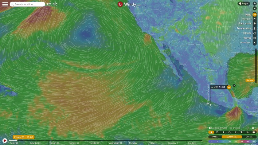
We knew a storm was coming, with increased south-easterly winds throughout the day, Saturday and into Sunday. Our plan was to fish a bit  Saturday, check out another anchorage, but ultimately head to our Read Island anchorage where we had anchored two times previously, one time with very strong southerly winds (which meant we were anchored off a lee shore)

We fished a few spots, but no luck, as the winds picked up to 15 to 20 knots, the seas inside Farragut Bay did also, with 3-foot waves. We decided to pull our shrimp pots, which in hindsight turned out to be a mistake. It was not fun with those winds and waves and stressed Ti out more than was necessary.

We then headed to the east side of Read Island, where we could anchor for the night, but first did another hour of fishing in a spot Ti had noticed a small fishing boat last time we were here.

Saturday, 25 July 2020 at 18:00. Radar and chart depiction of our anchorage.

About 17:00 Saturday, we were anchored in our Read Island cove. I let out 140 feet of chain plus our 30’ nylon snubber bridle. The spot we anchored was roughly the same as the first time when we had seeked shelter here during another storm earlier this summer. The initial anchor bearing was 80’ @ 243° in winds that were already SE to SW at 8 to 15 knots.

The previous storm had produced winds 15 to 25 knots in this cove. I was quite stressed as it was a lee shore, but we pretty much stayed right where we anchored. This informed my opinion for this coming storm.

06:30 Sunday morning wind graph

We were anchored in 37 feet of water under the keel. Had it not been off a lee shore, I would have let out another 100+ feet of chain.

The winds were 15 knots gusting to 25 thru the evening. By nightfall, it was raining heavily and between the rain and the darkness, I could not even see the nearby shore a couple of hundred feet away off our beam. Thus, the lack of any decent videos or pictures.

Just before midnight the winds came down a few knots, but as they say, this was the proverbial calm before the storm, as by midnight, the winds were rapidly building again. It was to last almost 24 hours, with half that time with winds above 20 knots, peaking to 40.

This is our 24 hr wind graph from at 17:00 Sunday and the previous 24-hr to Sat 17:00 (when we first anchored)

I was happy to go to sleep before then, but Ti was a nervous nellie, waking me up every half hour to tell me the wind was blowing, and the boat was rocking a bit (though not really). The first couple of times I got up to check everything to maintain marital bliss, if nothing else, as it was pitch black outside, with heavy rain and wind. I could see nothing. At midnight, the anchor bearing was little changed in direction or distance.

While the winds were high in this cove, there was really no swell or waves, at most a half foot, making it a little rocky, but hardly noticeable in the scheme of things.

I went back to sleep, but Ti would still wake me up a dozen times until morning; I’d reassure here and go back to sleep.

Civil twilight was about 04:00, with sunrise 45 minutes later, so that’s when I got up again, as I could no longer use the excuse to Ti that it was dark out and I couldn’t see anything.

Ti makes the best of our SUnday by making an apple pie as we are hunkered down.

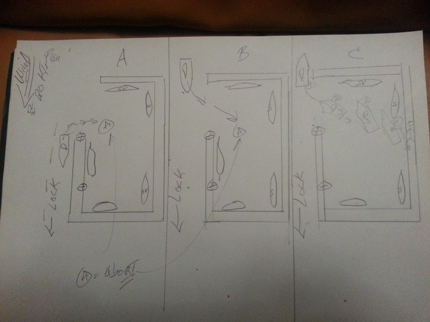
So I was up, in the pilot house, watching as the storm peaked about 06:00 with winds gusting to 40 knots and a steady 20 knots, but for the next 6 hours, while the wind gusts came down a bit,  the steady winds were higher in the 25 to 30 knot range. Thus, with that wind pressure, the anchor bearing distance oscillated between 156 and 174 feet for much of the morning, before decreasing to 110’ to 130’ by midafternoon. (and where it had been the previous evening).

My little diagram of our anchor in relation to the boat at its most extreme.

Looking at the little diagram I drew and my calculations, all the catenary was out at that point, 174 feet away, and we were simply being held by our Delta anchor. As the sun got higher in the sky ,I could see shallow rocks about one boats length away behind Dauntless. That confirmed my calculation to not let out more chain. I was also ready to start the engine should I notice us dragging. However, since we had not dragged at all, I was hesitating to move and thus possibly upset the balance we had obtained.

In analyzing the track on the Coastal Explorer C-Map chart and the Maretron wind graph, it was clear that we had spent about 12 hours between that 150 and 174 feet and by mid-afternoon Sunday, 22 hours after we had initially anchored, we had moved back to the original bearing and distance of 78 feet. Monday morning, when we finally hauled anchor after 36 hours, we had moved to within 60 feet of the anchor under calm winds.

The track of CE for 36 hours. The radius of the circle is 180′

All in all, I could not have been happier with how things developed and how rock steady we were under difficult conditions.

Would I do it all over again?

It’s hard to say. I would probably turn on the radar and set the alarms the next time. That would be more effective than anchor alarms (GPS based), which I don’t use anymore, because I find them ineffective.

My Alaska friends had told me that any location that may have been more sheltered from the wind would have been more open to waves and swell.

All in all, it’s hard to try to improve upon a good outcome. As they say, sometimes it’s better to stick with the Devil we Know, versus the one we don’t.

To see a little video of this, which I have not yet uploaded on my Dauntless at Sea You Tube channel, please visit the link  below and subscribe.

Dauntless at Sea You Tube Channel

Advertisement

What I’m Really Afraid Of?

Just when I thought I had the Plan, I read a story about drug driven crime spreading to the west coast of Mexico. Manzanillo, one of my planed stops, was prominently mentioned.

20180126 Win
dyty Depiction of Surface Winds

Where does that leave me? Besides the obvious, afraid!

Last summer I had a detailed plan to cruise up the coast of Mexico, stopping every night, hitting all the nice spots, with only a couple overnight passages. Let’s call that plan, the Coastal Cruise Plan. This is essentially what we had done 3 years ago in the Baltic.  I had even spent the last month alone, cruising from Stockholm all the way back to Ireland.

Last year, I had my nephew, Micah, with me from Ireland to Costa Rica.  It’s no coincidence that when he left Dauntless in March to go to law school, I lost a lot of my ambition to continue north alone. Cruising alone for me is not fun. It’s what I do when I need to get from A to B or as I did from Stockholm to Waterford.

20180126 NWS P_e_sfc_color

I am hoping that this coming summer, my girlfriend Trinh and her son, Thien, will have visas for Mexico. This is something that I must initiate this April when I return to Huatulco. If that is possible, they, with other friends who have expressed interest in joining Dauntless this summer, would make the Coastal Plan at least feasible. We would enjoy the numerous stops and towns along the coast, plus many eyes make for less stressful cruising.

A visa for the U.S. is another story and it takes forever. I’m hoping for 2019.

The Pacific coast of Mexico is not the Baltic and North Sea. The weather is not necessarily worse, but the predominant winds are from the northwest, the direction Dauntless must go. Adding to that problem, there are numerous fishing boats and nets and other boat traffic near the coast, whereas in the Baltic, there was none of that.

Lastly, safe harbors (protected from weather) on the Pacific coast of Mexico are few and far apart. North from Huatulco to Manzanillo, a distance of almost 600 miles, there are only two safe harbors. In a normal (for me) coastal cruise of 40 to 60 miles per day (6 to 9 hours), that’s 8 out of 10 nights anchored or in some port, at the mercy of the weather.

That’s a no-go.

For those of you who have read my precious comments about weather forecasts, you will know that even in the best circumstances, I don’t trust weather forecasts past three days and even at that I assume they are 50% off. That means, if the forecast is for winds from 270° at 12 knots, I plan for winds 240° to 300° at 8 to 16 knots (50% and 150% of forecast).

Therefore, to cruise an unprotected coast in any but the mildest of conditions is perilous.

I needed a plan B.  The Near Coastal Plan.

In this plan, we will take what the weather gives us. If we get four good days (favorable winds and seas) we’ll cruise until the weather becomes unfavorable. This potentially means we would take chunks of distance, 3 days, 24/7 is 450 nm. Making the entire trip into 4 chunks of 500 miles each, would get the job done and reduce time spent too close to the coast.

It would be far less fun however, but probably safer in many ways and less stressful.

Then came plan C, the Ocean Plan.

But first we talk to talk about hurricanes.

Hurricane season runs from June through October, with the highest frequency, mid-July to mid-September.

I can see an advantage in avoiding the high summer.  Looking at the Windyty depiction of the surface winds over the eastern Pacific today, you can see the big ass high pressure system that keeps the easterly trade winds over Hawaii (far left of picture) as well as the northwest winds over the west coast of California and Mexico.  Now, one of the disruptors of these winds are hurricanes.  The circulation pattern around hurricanes is far smaller than this massive high-pressure system, but a Pacific Ocean hurricane a few hundred west of Mexico, would cause southerly winds off the Mexican coast.

If it moved slowly north, maybe I could tag along??

It all depends on the situation and I’d have to figure out my escape routes, but it’s something for me to think about and plan for. It’s also significant that eastern Pacific hurricanes are weaker than Atlantic ones, with wind patterns not much stronger (if at all) than Northern Atlantic low-pressure systems in August and September (and I’ve certainly had my fun with those!).

Then the Ocean Route would entail an end around, running almost west, then curving slowly northwestward and finally northward, ending up east of Ensenada or southern California. With little winds, it would be an easy 10 to 12-day voyage, just like I did alone from the Azores to Ireland.  I’d only do this though if I saw the possibility of an extended time of light winds.

Also, time of year matters in my decision making. In the scenario just mentioned above, In May or June, I’d have plenty of time to wait or make it happen.  I may have different options later in the summer.

In September 2015, while waiting in Norway to cross the North Sea (I anticipated a 72-hour crossing), my weather windows were getting smaller and smaller. September is simply too late to be doing such a trip. But Sweden was so nice!

There had been strong northerly winds 25+ winds and driving rain, for days. I waited and waited. Finally, I saw a high-pressure ridge building into the North Sea from the English Channel, but this ridge of high pressure was also moving eastward.  But it only gave me a two-day window for a three-day trip.

Dauntless Crosses the North Sea 2015

I had to take it. It meant that I left my little port of Egersund, Norway, with 35+ knot winds from the NNW and rain. If you look at my route I took to Fraserburgh Bay, Scotland, those strong winds caused that dip in my route. Even with the paravane stabilizers, it’s just easier on the boat to put the winds and resultant seas on the starboard stern quarter. After 24 hours, as the winds died, I was able to head more westerly and on the third day, to the northwest. But that little longer route also added 12 hours to the trip and the next frontal system was right on, so my last 8 hours were in the weather again.

Would a longer, better weather window has come eventually? Sure. In the winter, under very cold air and high pressure. I couldn’t wait that long.

Dauntless in Ireland, next to a fishing boat with almost the exact same lines. There is a reason she handles the North Atlantic like she was born there.

When we decided to cruise the world or at least get away from the coast, we knew we wanted, needed a boat that that could all that and more. All the readings I did about boats and people cruising in boats all over the world, led me to Kadey Krogen.

Our little 42-foot boat was well built, extremely well designed for the worst of the worst and affordable.

Having Dauntless under my feet gives me confidence that she can handle any stupid situation I put her in.

Now, people are another matter.

.

Keys:


It’s Dark at Night

Each circle is 30 minutes.

As I look at the videos I shot with my phone conditions don’t look that bad.  Monday morning unfolded into seas that were still less than 6 feet.

With a “normal” day cruising, we should be in Vlissingen in 12 hours.

Error
This video doesn’t exist

The https://share.delorme.com/dauntless site is pretty nifty.  You can click on each circle and it tells you the time.  I can also see that I made the decision to abort and head for Oostende at 21:20 Monday night.  Only 12 nm away, it still took 4 and half hours to get here.

And those were the must miserable 4 hours.

The winds having built to 25 gusting to 33 knots, had built very steep, choppy waves.  Only 4 to 6 ft. early in the evening, due to the proximity of land, about 10 miles off our starboard beam, the waves were coming from a multitude of directions, having bounced off the close by land.

Pierre-Jean liked hand steering; he really liked the Krogen and I let him for the most part, though as the evening progressed, I preferred being on the ComNav Autopilot because it does really well in the worst conditions.  At a certain point it dawned on me that for PJ, this was a test drive.  He got to drive a Krogen in conditions that 90% will never see.  He was as sick as a dog, but I give him credit, he found a boat far tougher than he was.  He left happy.

Dauntless Docked. There was a Sailboat 10' in Front
Dauntless Docked 3 Days later. There had Been a Sailboat 10′ in Front

Me too.  PJ had left me with a bunch of wonderful French wine.  And if we have one rule on Dauntless it is all sins are forgiven with wine.

With the mixed up seas, Dauntless was being hit by the tops of waves periodically. So I not fixing the two problem areas, the warped pilot house doors needed new thicker gaskets.  The center pilot house window, that flips open, had a rubber flap, to stop water from directly hitting the gasket on the hinge.

I had removed that months ago, with the intent to replace it. I hadn’t.  Why, because I was looking for a white rubber mat, that would fit, be inexpensive and look good.  So periodically, as the pilot house got bath, water would splash down onto the helm.  Only a half a cup at a time, and looking on the bright side, I was happy that the water did not stay in the ceiling, but immediately drained down to the helm!

But still, a half assed oversight on my part.  So the helm was covered in wet towels.

The pilot house doors were another issue.  A lot of water was coming in, maybe a quart at a time.  There were a lot of times.

The Entrance to the Harbor From Shore
The Entrance to the Harbor From Shore. Just to the ld=ft of the tower you can see the two green lights that initially confused me

So for the last few hours that side of the pilot house floor was covered in soaked towels, mats and other materials so the water would not make a waterfall into the salon.

As there was no reason to move around, not so bad of a problem.   But as we were minutes away from the harbor entrance, I got soaked just moving around the pilot house.

Then to add misery to discomfort, I needed the pilot house doors to see what was where and get the lines ready.  So we had a 30 knot wind blowing through the pilot house it was cold, wet wind.  The Krogen has a tendency to stay at whatever the water temperature is. Thus, a 55°F water temperature meant at night the pilot house was about the same.  Add wind and being wet, just set the stage for a true disaster.

OK let’s set the stage.  I’m a mile from the entrance to Oostende harbor.  I see the red and green lights marking the channel, I also see two green lights, on the red side of the channel.  I see numerous Sodium vapor lights and the orange glow they produce.  With all those lights, I see no channel; only darkness and shadow.

But I have no choice.  I am in 20 feet of water, winds are up to 35 knots, waves are crashing into us from all directions, and there are all sorts of sand banks close to shore with all sorts of names, meaning they have a history, i.e. “remember when poor Jacques floundered on the Grote bank?”

The wind is pushing us fiercely to the south, to the right (green in Europe) side of the channel.  I am trying to keep the boat on the red side, but clearly still not seeing the entrance.

TheMarina Entrance
The Marina Entrance

Finally, I trust to the charts, C-Maps by Jeppesen, (did I ever tell you I was a Product Manager at Jeppesen?? you’d think I could get a discount on their charts!), aim for blackness just to the right of the last red marker and as soon as I enter the shadow, I can see the rest of the channel straight ahead and the seas flatten.

But this is big commercial channel.  I need to get the paravanes in.  Pierre-Jean has never done that before, so I must leave him in the pilot house, while I go to the fly bridge and winch them up. It only takes two minutes and I am thankful that all the tweaking I have done on that system works so well.

I race back down, and aim for the right channel which will bring us to one of three marinas in the harbor.

I am cold, wet and miserable.  I’ve gotten only a couple hours sleep in the last 24; but this is where I am pleased with my decisions.

As we motor slowing down the channel, maybe a mile, I am conscious of the wind pushing us along.  I want to reconnoiter the marina, but not get us in a position I cannot get out of.

Sure enough, as we get to the slips, mostly short (30’) finger piers, there are no “T”s and the left side of the marina which has longer docks is filled with small ferries.  I am adept at making the Krogen do a circle in about a 50’ diameter without using the bow thruster.  While docking I turn on the bow thruster, an electric Vetrus, but try not to use it as my experience has been bow thrusters are like banks.  If you need it, it won’t be there.

So on a calm day, no current, bow thrusters work great.  But this is not that kind of day.

The Dutch Boat on the right is tied to the dock right after the slip.  This is where I initally docked and let PJ off. In Hindsight, I too Could have stayed there.,
The Dutch Boat on the right is tied to the dock right after the slip.
This is where I initally docked and let PJ off.
In Hindsight, I too Could have stayed there.,

I decide there is no room here.  Though I keep in the back of my mind the possibility of rafting to one of the ferries.

We then proceed back to the other marinas, right near the entrance to the harbor.  It is a narrow entrance that widens after the opening.

The one long dock is occupied by one of those new plastic, three story, small penis boat. Clearly American, though it says Bikini on the back and flies no flag.

Turns out there was room on the opposite side of the same dock, but that would have meant I had to go around the end of the dock to an uncertain fate and after all I went through I was not about to snatch defeat from the jaws of victory.

So we proceeded towards the third marina and a set of locks, which while closed did have a waiting dock that I could use.  We looked around and did see a spot, along the inner dock, maybe 55’ long, between two sailboats.  It was in cul de sac and just opposite the waiting dock.

We prepared a midships line and I tied to the waiting dock to think about what to do.  The bow is facing the lock and southward, the empty 55’ spot is 100 on our left beam and the wind is coming from the stern at 20 knots.

I figured I could stay at the waiting dock until early morning, but my problem in situations like this, is that I do not sleep, anticipating the knock on the hull telling me in a foreign language that I cannot do whatever I am doing

There was also a seaweed covered wall, 50’ high, but we saw nothing to tie to.

So, I decided the spot between the two boats was feasible.  But with one caveat, Pierre-Jean had to be on the dock.  I would then throw him the midships line we had prepared.  That way, once a line was on the dock, he could control my movement to the sailboat behind.

He was a bit dubious, maybe he thought I was going to leave him, but I liked it and it was the only way I would attempt that spot. (The waiting dock was connected to the other dock, like three sides of a box.

And it was a box I was going into to.

Plan A:

My first attempt was halfhearted.  The boat was facing south, wind from our stern and I thought just maybe if I put her in reverse, I could use the bow thruster to push the bow around 180°.  At about 90°, abeam the dock and piling I had just left, the wind was pushing the boat so hard, this was not going to work in a million years.  I gave it full left rudder, full throttle forward to kick the stern away from the pole and pier. No problem, just a little too close.

Plan B:

Let with wind take me in forward, I’d through the line to PJ, out her in reverse and PJ could pull us into the slip.  With the wind behind us, I was going too fast from the beginning.  When I slowed, I had no way and no control.  I backed up and got out, just narrowly missing that same f…ing pillar.

Plan C:

Just like in NY, I would parallel park.  After all the above shenanigans, this turned out to be easy.

A Diagram of the Three Attempts
A Diagram of the Three Attempts. North is on top, and the wind is from the North

I backed into the box at an angle aiming for the empty spot but wanting to keep the bow close to the sailboat that would end up in front of us.

When I was abeam the stern of the sailboat, I threw PJ the line and he put it on a middle cleat.  I yelled at him to watch the stern and I would watch the bow.  He would control how far back to let the boat go.

Worked as planned as and with less drama than anything else I had attempted that night.

Dauntless on the other hand looked at me when it was all over, yawned and thought, “All in a day’s work”.

And as I thought about it, happy to be lying in my warm bed, with no new scars to deal with, I realized though the worst of it, while I was certainly unhappy; there was no noise from below.  The salon, the staterooms, the engine room, nothing was banging, rolling around or otherwise out of place.  Books stayed on the shelves in all three rooms, and pother than the second monitor in the pilot house that I had to re-secure, everything was battened down.

A great boat is a sea way.

I hung up all the wet things and at 3:00 a.m. took a hot shower, crawled into bed and was ever grateful that I had remember to turn on the 12 v heating pad a few hours earlier.

With that, All’s Well that Ends Well.


The Calm Before the Storm II, But New Problems Develop

Day 6 & 7, 23 & 24 August

Back on course, heading due north, the winds were directly behind me, at 180° at 15 kts (written 18015).  Can’t ask for any better than that.  I was fat, dumb and happy.

Following Seas
Following Seas

I experimented a bit.  I wanted to see if different speeds affected the rolling. So between 1400 rpms, which produced about 5.1 knots and 1700 rpms which produced 6.7 knots, the boat rolled about 07° in one direction.  So no real difference, I did notice that with a following sea, the paravanes were less effective than I was accustomed to.  With those same waves on the beam, the roll would have been less than 04°

I also played with the autopilot a bit.  I must give the ComNav Autopilot credit.  I do not like the way the manual is written as I find it so dumbed down, it’s almost nonsensical, but the autopilot itself works well.

Now, the big caveat, is that with the confusing manual, it took me a year to get it to work well, but it f=does a good job and it really excels under severe conditions.  I had no backup for the AP and in the future I will have to address this, as this trip could not be possible without it.

So I set the AP to “auto” mode, where it decides the settings based on how rough it thinks it is. This ends up working fine until it got really rough and then I had to change it to the most sensitive setting to get it to work well.

I was disgusted looking at my track and seeing that I was only 125 nm from my position on the 21st at 7:00 a.m., that’s two days and 3 hours ago, I was pissed. If I wanted to make progress like that, I’d have a sail boat! I could have put the boat at idle, kept the course NE and I would have save a whole bunch of fuel, time and aggravation.

I’ll spend the next 24 hours being irritated at every glance at my navigation program seeing this track that did nothing other than waste time, money, fuel.  Thankfully, what I didn’t know was that by adding 36 hours to this passage, I was setting myself up for a ride of the ride of a life time.

I also added 2.5 qts of oil to the engine while it’s running. It uses almost 2 qts per 100 hours, so I just guestimate.

In the middle of the night, We get hit by a 36 kts gust of wind from the west. It made the boat roll 15° and woke me up.  The rest of the morning, the winds stay westerly but die down to 10 to 15 knots. This was the end of the nice weather.  The barometer, was 1015 mb and starting to fall.

I’d pretty much been  running off the port tank since leaving Horta. This tank was not down to 40 gallons, so it was time to start using the new fuel.  As I’ve said before, I try not to run any new fuel to the engine that has not been polished (cleaned and very finely filtered). This system works well had I got the fuel earlier and then spent a day polishing it while before leaving.  This issue is, I can only polish from the tank that is feeding the engine.

So now on the 24th, I figured I better see what’s going on with the fuel again.  I opened both feeds, so I could polish the starboard tank, but the engine would probably still take most of its fuel from the port tank.  I closed the return to the starboard tank, so as fuel was polished (filtered) it was also transferred to the port tank. The idea here is that if I have crap in the starboard tank, it stays there, hopefully.

So all day, we polish and feed from both tanks, returning fuel is all going to the starboard tank. As I go do my evening check, I am shocked to see the FP is really full of crap.  What does crap look like, large flakes of black/brown material the size of a dime and smaller, plus water. Now, I had run this FP about an hour after getting the fuel on the 18th.  It had rapidly clogged the filter, but this has happened before and that’s why I have the FP. So, I had put in a new filter before polishing again.

We ran like this for two days.  At the end of the first day, not only did I have a dirty FP filter, but the  filter feeding the engine did not look good.  This was the first time, I was really concerned because I do not like that this primary engine filter collected so much crap.  (the engine also has two filters in line, called the secondary filters that are actually on the engine, just before the fuel injector pump).

So after 24 hours, I switched the feel to the other filter.  The next day I changed all three filters while we were running.  For some reason known only to the gods, as I primed the right side filter, it was fine, but when I sent to prime the left side filter, I didn’t know what I did, but within about 20 seconds I could hear the engine starving for fuel.

Damn, I spend 4 weeks not turning off the engine and now, even worse that stopping it on its own, I let it run out of fuel, which can introduce air into the fuel lines.

What a BOZO!

Luckily, Larry and Lena, another KK42 couple, had spoken to me last summer in a most effective manner, “stop dicking around and put an electric fuel pump on so you can prime your filters in seconds. You don’t want to be using the lift pump lever with a hot engine”  Since I had just worn a hole in my hand using the lift pump lever for the three days I had been trying to get the engine started, I listened and did as told.  It had already helped in countless ways, in fact, I had just used it to prime the right side filter.

A clue as to what happened.  Another problem with running alone, now I must extradite myself and run up to pilot house and start engine. It starts and runs for 10 seconds. Then silence, punctuated by that loud low oil pressure buzzer. Another sound you never want to here, unless you just turned off the key.

OK, what now, I open the bleed screws on the engine filters.  I haven’t had to do that in ages, in fact since the electric fuel pump addition, but just maybe…

Turn on electric fuel pump, and nothing.  What the hell?

Look at my valve positions again and notice that everything is closed. Umm, turn on the main line and fuel sprays out of both bleed screws onto the hot engine.  Luckily, it’s diesel, which allows you to do such stuff without turning into a Molotov cocktail.

Get my little rag, wipe down the top of the engine and the filters. Run up to the Pilot House and turn the key. It starts, but slowly, then I give it some throttle and it roars to life.

Back to the engine room, make sure everything is set to run, turn on FP again and off we go.

I had done all of this early in the afternoon, the winds were still only 10 knots, but by 21:00 they were southwesterly 25 gusting to 30, as the barometer took a rapid dive to 1010 mb, losing 4 mb in 6 hours.

I had no idea that these would be the best sea conditions I would see for the next 5 days.

The Beginning
The Beginning

America’s Race – The Daytona 500 – It’s just not about $$$

As Dauntless gets prepared for her paravanes, I took the opportunity to attend the Daytona 500 with my friend Richard, from Providence, RI, who will be spending time with me on Dauntless in Florida.

USAF C-5 Support Plane for the Thunderbirds
Sunrise & a USAF C-5 Support Plane for the Thunderbirds

Not my first NASCAR race, as my first race I attended in person was in Riverside California in 1981.  See those big, really big cars racing up thru the “S” curves was truly something you had to experience.  Having been a Richard Petty fan since the early ‘60s (I still cringe when I hear the name David Pearson), he had no chance on a road course, but it was a wonderful experience.

An experience I probably took for granted.  You could wander anyplace around the track.  You could bring in your own food, booze and beer.  In other words, it was an affordable experience, especially for families.

Now, fast forward 33 years, and I, who can be critical of many things, found this race to truly be America’s Race for these reasons:

  • It’s fan friendly.  They actually act like they care, no love their fans.  In the early morning hours, I was able to walk just outside the catch fence, all the way around the track.  To watch the sun get ever higher in the sky while on top of the 33 degree bank is awesome.
  • It’s affordable.  While the dopes in major league baseball wonder where the fans are, as they have made their venues unaffordable for families, NASCAR welcomes fans.  Bring your 14”x14” cooler filled with whatever suits you.  Families can picnic. You can buy affordable food, $4 hot dog, $8 steak sandwich, $6 beer 16oz too!
  • Virtually no areas in the grandstands are off limits.  Move to a vacant seat, no problem.  Just wander around, seeing where you like the view best to watch the action, no problem.
  • A diverse fan base.  It doesn’t come across on TV, but the fan base pretty much reflects all Americans, both in age and race.
  • I did not even get the Fan Pass (that allows you into the infield until the race begins), but drivers are accessible to fans.  It’s the opposite of Formula One, where they seem to make a real effort to highlight the difference between them and you.
  • They had a kid’s event with driver Jimmie Johnson.  Kids less than 12.  They got to build, yes, build, with hammer and nails, a wooden race car.  As many girls were doing this as boys.  Really inspiring to watch them hammer away, and while they were given goggles and apron, some wore it, some didn’t.  Interesting concept, teach personal responsibility young.
    Girls 7 Boys building thier cars with Jimmy Johnson at Daytona
    Girls & Boys building their cars with Jimmy Johnson at Daytona

    Kid's event with Jimmy Johnson at Daytona
    Kid’s event with Jimmy Johnson at Daytona
  • And that leads me to my last point, no nanny state here.  Even with lightning and thunder right next to the track, the announcements were very clear; “you were responsible for your own personal safety” it was up to you to stay in the stands or leave.  Even when the tornado warning was announced.  I was pleased to be treated like thinking adult.  All the lawyers who run this country must be up north.

All in all, one of the most enjoyable sporting experiences I have had in the last 20 years. A truly iconic race.

If you like any kind of racing, then check out a NASCAR race at a track near you.  You may be surprised.

more pictures at:  http://dauntless.smugmug.com/Misc-Public/i-vRr6jLd

How I almost Snatch Defeat from the Jaws of Victory or When a Shortcut, Isn’t!

Chubb Cay to Dollar Harbour, 30 January 2014, Thursday,

It’s Oh Dark Thirty, really, 3:00 a.m.  If I want to get to Cat Cay today, it’s 76 nm @ 6.5 knots, that’s 12 hours, plus the usual hour of hijinks, so I either leave now or drive in the dark. Since for the first few hours this morning I can follow the route I took back in December, it’s better for me to leave now in the darkness, but on a known route.  I also can’t wait to try my new driving lights, but as there is nothing in front of me, I don’t see anything.

Hauled anchor, at 3:45 a.m. and am now underway.  I’m very close to the cold front.  Forecasters had it between Florida and Bimini, but the winds switched around last night to the NW meaning it or part of it, passed thru, however, as I get underway, I notice the winds are again from the SE and I can sense buildups just to my west.  Sure enough, in about an hour, I am going thru heavy rain for about half an hour.  Once again I am passed the front, hopefully this time for good. (Sadly, was not the case and the third time, was at the most critical time.) As the sun came up at 6:30, the very light NW winds just caused barely a ripple on the ocean.  Good cruising weather.

I picked up a hitchhiker for about half an hour.

A Tern Takes a Ride
A Tern Takes a Ride

Been anchored here in Dollar harbor (thanks to Active Captain) 30 minutes, since 17:15, a 14 hour day,  just got out of the shower and now, finally It’s Miller Time, but I’m having stiff drink.  As my mother would say, a highball.

So let’s go back to the videotape. The plan worked well. Would have worked even better had I remembered to look at my Explorer Chart Book of the Bahamas, which was three feet away on the chart table in front of my face all f…day.  (the downside of getting up at 3 a.m.?)

So all was going well.  By leaving so early, the seas were flat for the first 9 hours, it wasn’t till early afternoon that the southerly waves picked up in the shallow water west of the tongue of the ocean.  Small waves about a foot, but once in a while they would hit the boat strangely and cause a disconcerting thump.  I’m making good time too, 1600 rpms, but averaging 7 knots.

At this point, it’s midafternoon and I’m only about 10 nm Southeast of the Cat Cay lighthouse, and I am following the exact route I took coming out, but am wondering why I took that route as it seems a little off from what my Navionics charts are saying.  Especially when I got to the real shallow area that I had come straight thru last month.  Shallow, so cruising slowly for an hour, like 5 kts, with only 1 to 3 feet under the keel.  Luckily, as the water got skinny, I made sure I was exactly on that track, though I did test it, by going north and south of the track to see if it improved. It didn’t.  OK, so I get thru that part and now I’m 3 nm SE of the lighthouse, but it my Navionics says I can try to get to Dollar harbor by coming from the NE on the east side of South Cat Cay.

Interesting. Not one to pass up an opportunity (to save an hour)I slow down even more and give it a try, within minutes the rudder becomes sluggish, I immediately make a sharp U turn and add power as the depth sounder stopped sounding, which means it’s in the mud, sand.  Within a heart stopping  30 seconds, I have at least some water underneath.  OK, all is good, I retrace my steps, get back on course a and once again head NW to the lighthouse and the gap between South and North Cat Cay.

Now, in part because of the wasted time, this storm that has been building is now here, so I go thru the narrow cut south (must hug shore to within 100 ft) of the lighthouse in raging seas and wind.  100 m visibility in heavy rain and wind.  When I get to the west side, it is far worse, as there seem to be two different wave trains and their both 6 to 8 ft.  I realize at this point, that I need sea room no matter  what the seas, so I continue west into the deeper water, >40ft, before I turn South,

Now, I’m wondering what to do, The rain is so heavy, I can’t see the inlets or the rocks just to my left, I don’t trust my chart plotter or my navionics App and the wind is from the North, so continuing on and crossing the Gulf Stream is out of the question.

A light dawns, Like the sun burning though the morning fog, I remember my trusty Explorer Chart Book.  Open it to the pertinent page and low and behold it has all the answers.  It showed why I had previously taken the route I had, plus it showed that the only way to the Dollar anchorage was from the southwest.

I decided to play it safe for once and come all the way south of Wedge Rocks as the channel there looked a bit deeper and wider, on the chart, so I just gritted my teeth and accepted that I would have a rough ride for the next 30 minutes.  The visibility was still bad enough I could not the rocks or breakers, so I wondered about turning into the inlet when the time came, but as it was it was all anti-climactic.  As soon as I was south of the rocks, I turned, and the seas died down to just 2-3’.  Looking at the chart it confirmed the AC advice and it was a piece of cake.  I had 14 ft. of water all the way to this anchorage. There was some wind, but absolutely no boat movement (and for a full displacement boat, that says a lot).  There is a strong current which is keeping Dauntless parallel to the channel, but this is the quietest anchorage I have had in the entire time in the Bahamas.

Here are two videos, but it’s hard to get WordPress to play nice with pictures. So go to http://dauntless.smugmug.com/Dauntless-Public  for the rest of the pictures in descending chronological order.
Finally,  It’s Miller Time and here is one of my favorite Miller time T-shirts at http://dauntless.smugmug.com/Dauntless-Public

Error
This video doesn’t exist
Error
This video doesn’t exist