I’m not in it, at least not in the Wrangell, Alaska version. Even NYC has a version, with people going in the water at Coney Island on the first of the year.
Now the Wrangell version is for these hardy enough to brave the cold waters (50°F) of Zimovia Strait on the first of the new year. This winter has been extremely wet, but not very cold, with temperatures staying above freezing except for just of couple of dry days in the high 20°s. Every other day we’ve had clouds and rain. Contrast that with last year, where by this time, we’d had few feet of snow since before Thanksgiving until now and had weeks of below freezing temperatures.
Our Marina on a rare sunny day
I do have my Polar Bear certificate for being in Resolute, Northwest Territories, Canada, but I just had to be there, not do anything special.
While on T-3, I did have the opportunity to jump into the Arctic Ocean, in the six-foot diameter hole we had melted thru the sea ice to collect zooplankton samples for the summer. But the idea of jumping into water that was 28°F, even then, in the years when I was young, brave and knew everything, was unappealing to me.
I pictured myself going into shock, not being able to drag myself out of our four-foot-deep ice hole, while my bumbling colleagues came up with a way to drag me out as I died of hypothermia.
Being on the Arctic ice pack in the middle of summer was fascinating. During the summer, with 24 ours of daylight for five months, the sun did produce significant melting of the top layers of ice.
Now, a little lesson on the Arctic ice pack. The ice pack was (until recently) only about 4 to 6 feet think, absent pressure ridges, (areas where the ice has been pushed into little hills by wind and current). Currently, the ice pack has thinned to just 3 to 4 feet. Thus, much larger areas are opening up during the summer melt.
The ice pack grows from underneath, fresh water freezing in the 28° water. Thus, the ice pack is all fresh water and was the source of our drinking water. We melted ice most of the year, but for two months of the high summer, we would pump fresh water from the numerous lakes that formed on top of the ice. These melt ponds would be a beautiful blue in color. On the other hand, when we would come upon leads (a break in the ice pack) in the ice, the water would be as black as the blackest night. I found them actually scary, I would not get within a few feet of them. Terrified would be more like it. Even after all these years, nothing has made me feel that primordial fear like those black, black leads.
The Arctic Ocean doesn’t get very much snowfall, it’s simply too dry. So, all the ice growth comes from below. While all the ice melt or sublimation (solid, ice, becoming gas, water vapor, without turning to liquid first. Sublimation is how most of the ice disappears. Therefore, the ice pack is always growing from underneath 10 months of the year and losing ice from above throughout the year, but especially in high summer, June and July.
If you would like to know more and be up on Arctic Sea Ice News & Analysis, check out this link, which I look at every months as I dream of cruising from Alaska to Europe one day:
20200725 Anchoring on a Lee Shore in a Gale in Southeast Alaska – The Devil You Know…
Our track around Farragut Bay ending in the east side of Read Island (as depicted by green boat)
As I have said before, this is my 7th year with Dauntless and 6 years with my 55# Delta anchor, so I sleep well at night on the hook.
We were cruising from Wrangell to Juneau, 148 nm, normally three days, but we wanted to do some halibut fishing and we didn’t need to be in Juneau until the following Wednesday, giving us 6 days.
We left Wrangell Friday morning on an out-going tide, giving us a push through most of Wrangell Narrows. Outside of Petersburg, at the north end of Wrangell Narrows, the current will abruptly change from a plus 1 knot to a minus 4 knot current. When this happens, we anchor just off the channel and wait a couple of hours for the slack. That’s what we did on this day also.
Even with our stop of a little less than two hours, we arrived in Farragut Bay about 20:00 Friday evening, dropped out shrimp pots and crab pot and anchored on the south side of the large bay. It is an open anchorage, but suitable for good weather with no swell.
We knew a storm was coming, with increased south-easterly winds throughout the day, Saturday and into Sunday. Our plan was to fish a bit Saturday, check out another anchorage, but ultimately head to our Read Island anchorage where we had anchored two times previously, one time with very strong southerly winds (which meant we were anchored off a lee shore)
We fished a few spots, but no luck, as the winds picked up to 15 to 20 knots, the seas inside Farragut Bay did also, with 3-foot waves. We decided to pull our shrimp pots, which in hindsight turned out to be a mistake. It was not fun with those winds and waves and stressed Ti out more than was necessary.
We then headed to the east side of Read Island, where we could anchor for the night, but first did another hour of fishing in a spot Ti had noticed a small fishing boat last time we were here.
Saturday, 25 July 2020 at 18:00. Radar and chart depiction of our anchorage.
About 17:00 Saturday, we were anchored in our Read Island cove. I let out 140 feet of chain plus our 30’ nylon snubber bridle. The spot we anchored was roughly the same as the first time when we had seeked shelter here during another storm earlier this summer. The initial anchor bearing was 80’ @ 243° in winds that were already SE to SW at 8 to 15 knots.
The previous storm had produced winds 15 to 25 knots in this cove. I was quite stressed as it was a lee shore, but we pretty much stayed right where we anchored. This informed my opinion for this coming storm.
06:30 Sunday morning wind graph
We were anchored in 37 feet of water under the keel. Had it not been off a lee shore, I would have let out another 100+ feet of chain.
The winds were 15 knots gusting to 25 thru the evening. By nightfall, it was raining heavily and between the rain and the darkness, I could not even see the nearby shore a couple of hundred feet away off our beam. Thus, the lack of any decent videos or pictures.
Just before midnight the winds came down a few knots, but as they say, this was the proverbial calm before the storm, as by midnight, the winds were rapidly building again. It was to last almost 24 hours, with half that time with winds above 20 knots, peaking to 40.
This is our 24 hr wind graph from at 17:00 Sunday and the previous 24-hr to Sat 17:00 (when we first anchored)
I was happy to go to sleep before then, but Ti was a nervous nellie, waking me up every half hour to tell me the wind was blowing, and the boat was rocking a bit (though not really). The first couple of times I got up to check everything to maintain marital bliss, if nothing else, as it was pitch black outside, with heavy rain and wind. I could see nothing. At midnight, the anchor bearing was little changed in direction or distance.
While the winds were high in this cove, there was really no swell or waves, at most a half foot, making it a little rocky, but hardly noticeable in the scheme of things.
I went back to sleep, but Ti would still wake me up a dozen times until morning; I’d reassure here and go back to sleep.
Civil twilight was about 04:00, with sunrise 45 minutes later, so that’s when I got up again, as I could no longer use the excuse to Ti that it was dark out and I couldn’t see anything.
Ti makes the best of our SUnday by making an apple pie as we are hunkered down.
So I was up, in the pilot house, watching as the storm peaked about 06:00 with winds gusting to 40 knots and a steady 20 knots, but for the next 6 hours, while the wind gusts came down a bit, the steady winds were higher in the 25 to 30 knot range. Thus, with that wind pressure, the anchor bearing distance oscillated between 156 and 174 feet for much of the morning, before decreasing to 110’ to 130’ by midafternoon. (and where it had been the previous evening).
My little diagram of our anchor in relation to the boat at its most extreme.
Looking at the little diagram I drew and my calculations, all the catenary was out at that point, 174 feet away, and we were simply being held by our Delta anchor. As the sun got higher in the sky ,I could see shallow rocks about one boats length away behind Dauntless. That confirmed my calculation to not let out more chain. I was also ready to start the engine should I notice us dragging. However, since we had not dragged at all, I was hesitating to move and thus possibly upset the balance we had obtained.
In analyzing the track on the Coastal Explorer C-Map chart and the Maretron wind graph, it was clear that we had spent about 12 hours between that 150 and 174 feet and by mid-afternoon Sunday, 22 hours after we had initially anchored, we had moved back to the original bearing and distance of 78 feet. Monday morning, when we finally hauled anchor after 36 hours, we had moved to within 60 feet of the anchor under calm winds.
The track of CE for 36 hours. The radius of the circle is 180′
All in all, I could not have been happier with how things developed and how rock steady we were under difficult conditions.
Would I do it all over again?
It’s hard to say. I would probably turn on the radar and set the alarms the next time. That would be more effective than anchor alarms (GPS based), which I don’t use anymore, because I find them ineffective.
My Alaska friends had told me that any location that may have been more sheltered from the wind would have been more open to waves and swell.
All in all, it’s hard to try to improve upon a good outcome. As they say, sometimes it’s better to stick with the Devil we Know, versus the one we don’t.
To see a little video of this, which I have not yet uploaded on my Dauntless at Sea You Tube channel, please visit the link below and subscribe.
Docking Dauntless at Heritage Harbor, Wrangell, Alaska
We went to drop one crab and two shrimp pots. This video shows the last 15 minutes are we return to the Heritage Harbor, Wrangell, Alaska.
We back into our slip for the convenience being able to get on and off the boat via the stern and swim platform, plus it’s a little better for the shore power connections.
A few things to note: With a single screw and no bow thruster, Dauntless has always been a handful to get in and out of tight places. But as time as gone on and I’ve bounced off enough objects, I am pretty skilled at backing her up. She has a left-handed prop, meaning the prop rotates counterclockwise. This causes a produced prop walk to port, I have to keep about 3° of starboard rudder to go in a straight line.
She can turn 180° to port in about 60-foot diameter but turning to starboard can be problematic as I discovered one day while trying to turn on the River Maas in the Netherlands. While the current was against me, a 30-knot wind from our stern made turning around to starboard impossible as I discovered halfway thru the turn. The bow just stopped coming around. Luckily, at this point, I had plenty of room to turn the other way.
A couple of hours later, having already forgotten what I just learned, I tried again in a small harbor to dock into the wind. (See the picture below ) To my horror, as the boat crabbed upstream and towards a boat tied perpendicular to the dock I was trying to reach, I rammed the dock with the bow, knowing that at least then, it would stop my progress towards this other boat 60 feet away.
Dauntless in Nijmegen. I had come on on the left (side of picture) to turn right to dock as you see, but wind was blowing 30 knots from astern (on the bow on).BTW, this was with a working bow thruster. Another reason I learned it’s best not to depend on one for when you really need it against high winds or current, it will be least effective.
Lesson learned.
Now when you see me make a 270° turn to port coming around to 90° to starboard from our original heading, you’ll understand why I take the long way around.
A look Inside at Dauntless, a Kadey Krogen 42, built in 1988
I’ve been asked to give a little tour of Dauntless. Built in 1988 by Kadey Krogen, designed by James Krogen, this 42 foot boat has been the best economical paggagemaker of all time.
With two cabins, one mid-ship portside, the main forward, each with a head & shower. A very efficient boat inside and out.
Safe in towering seas, she just rolls along no matter what I ask her to do.
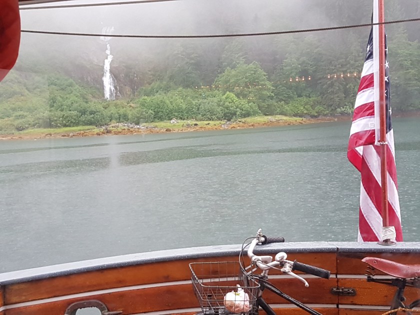
Anchoring at Kutz Inlet Waterfall, Inside Passage, BC
Highlights of this day include:
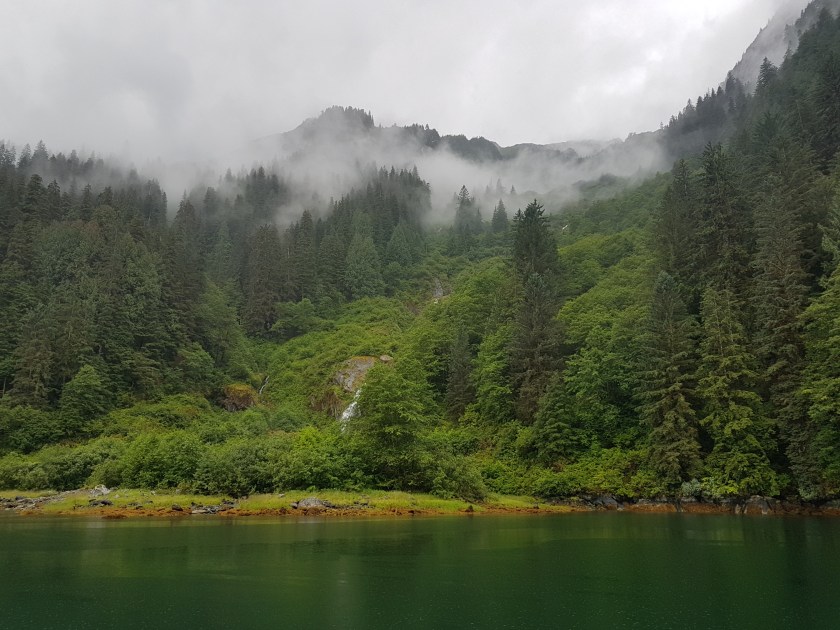
Another beautiful day on the Inside Passage in British Columbia.
Passing thru Sloop Narrows, Klemtu Passage
Anchoring in front of Kutz Inlet Waterfall
Having to re-anchor because I had anchored on a steep underwater slope, so suspected the holding would not be good. It wasn’t.
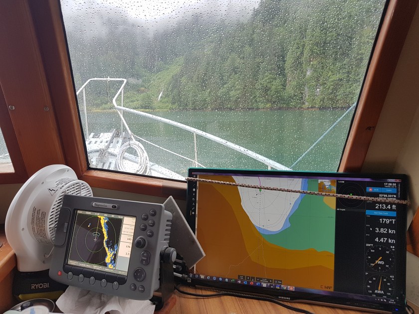
Our first anchoring was at 17:46. We were anchored in 20’ to 32’ of water, as it was a steep slope. I suspected the anchor had not set on that slope, so I watched it carefully. Here is what I saw:
17:46, Initial anchor bearing 48’@ 142°, depth under the keel, 32’
While the anchor was holding, I no longer liked the spot we were in. There were now two other boats in the anchorage, and they were more than a ¼ mile away. Maybe I better join them?
So, we moved. At 18:46 we were anchored in a new spot, much further from shore, but still on a slope. Bow anchor bearing was now 72’ @ 248°, I had 90’ of chain out in 40’ of water. I decided to put the stern anchor out. It’s a plow anchor with 10’ of chain and 300’ of nylon rode. This was just in case the bow anchor was not well set on the slope it was on.
For the next two hours I watched it. With two anchors out, I used the waterfall itself as a reference. The distance did not vary by more than 15 feet, I felt this was OK. Though our depth under the keel continued to lower as the tide went out. And because I had two anchors out, I did not have much scope on either line, with only about a 100’ out for each in 30’ of water.
But I wasn’t worried and with 12’ under the keel, I went to sleep, planning on an early departure the next day, so we could get to Prince Rupert, BC in two days.
I slept so very well. In my first years anchoring, I would awake every couple of hours, lay in bed feeling the motion and within a minute, convince myself that we were float free and clear. I’d then check the anchor alarm (Drag Queen), notice that it had turned itself off, so would get up to check that all was good. It always was good. In other words, my imagination was worse than the reality. I then go back to sleep, only to repeat the process a couple of hours later.
By years 3 & 4, waking up became less routine on the hook, as my 55# Delta anchor never dragged. Though I would still check occasionally in the worst weather.
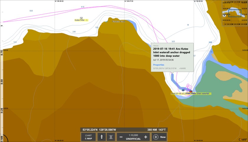
This highlighted track shows the route we took when Dauntless got impatient and left.
In the last couple of years, I’ve become even more relaxed about anchoring. Having used the anchor alarm in years, mostly because I found it only went off, after I took the dingy to shore and was walking downtown. Additionally, my first-year anchoring miscues were not so much about the anchor dragging, but me anchoring in the wrong place with not enough water under the keel at low tide.
I wouldn’t call it complacent, I was finally just comfortable anchoring, knowing my boat and anchor. To a point where even last month, on our trip to Juneau, we had to shelter from a first storm in Farragut Bay. We anchored in a little cove that I had anchored in two times previously. While it was a lee shore, in that the wind was pushing us towards the shore just behind the boat.
All thru the night, Ti would wake me up every 20 minutes to tell me the wind was blowing as the boat rocked back and forth. The first time I did get up to check, but with 40 knot winds and rain, I couldn’t see anything, but could tell from the chart we were 172’ from the anchor, just where it was when I went to bed. I didn’t get up again.
Writing about this now, I will make my next video of this day, so you can see the charts.
Back to our story.
I woke up at 6 the next morning and almost always immediately upon waking up, I would get up and do a quick check even before I put any clothes on.
This morning, I knew we wanted to get underway, so I figured I’d take the 10 minutes to do my morning toilet, get dressed, then haul anchor, get underway and make coffee.
That plan worked so well.
So well in fact, that I even went into the engine room to check the oil level before I came up to the pilot house. Larry was still sleeping in his cabin, when I looked out the pilot house windows and noticed we were already underway!
We were a ¼ mile from where we were the previous night. I can determine from the Coastal Explorer track that we started drifting about 02:00, so in 4 hours we drifted a quarter of a mile down the inlet about ¼ mile from shore with depth now more than 200’
I figured Dauntless was in a hurry to get underway, so I obliged her.
Hecate Strait to the west. The magenta line (on the right) is the route we took up the Inside Passage
20190715 North on the Inside Passage in BC, Bella Bella to Mouat Cove and onward thru Reid Passage.
The chart shows why the Inside Passage is so special, sheltering one from hundreds of miles of open Pacific ocean swells and waves.
Highlights of this day and a half include:
Another beautiful day on the Inside Passage in British Columbia.
Anchoring in Mouat Cove
We take the dingy for a short spin
Departure from Mouat Cove
Going through the narrow passage of Reid Passage
Mouat Cove
We took the dingy out to explore Mouat Cove, a beautiful little stop about midway along the Inside Passage. We managed to not hit any rocks, wither with the dingy or with Dauntless.
On these two and a half days, 13, 14 and 15 July 2019, Dauntless continues her northward trip up the Inside Passage in British Columbia to Alaska.
Highlights of this day include:
We race the Alaskan Ferry Columbia
We have a freshwater leak that empties our only full water tank
We stop early to rebuild the water maker, which only takes about 4 hours, only to discover that it didn’t solve the problem
Each day was 65 nm in 9 hours and 30 min on the 13th and just over 10 hours on the 14th.
First half of day 3, was just from Sea Otter Inlet to the Bella Bella dock where we hoped to get water for our freshwater tanks.
Low lights consisted of us spending 6+ hours rebuilding the Katadyn watermaker high pressure pump only to discover it did not solve the problem of the oil seal that was in the electrical motor portion of the water maker.
Upon close inspection, I had suspected as much before we started, but I was hoping for one of those boating miracles that was not to be.
For some reason, there does not seem to be a lot of places to stop and get fresh potable water along the BC portion of the Inside Passage. The cruising guide did seem to indicate that water was available at Bella Bella, so that was our destination on the morning of the 15th.
Once docked, we found the hose, but it took me 15 minutes to figure out how to turn on the water. The valve was hidden just beyond alittle gate that made it difficult to see.
Once that was done, we filled both tanks and got underway to anchor for the night a few hours north in Mouat Cove.