A Kadey Krogen Delivery

It’s been a quiet winter. Covid-19 or not, winter in Wrangell, Alaska is quiet. It’s possible to go weeks, without talking to anyone, other than the cashier at the grocery store.

Coupled with the fact, that until summer 2019, I had spent most of my winters overseas, my friends got accustomed to not calling. No cards, no letters, no nuthin., Great for hermits, not so great for a kid born in Greenwich Village, in what seemed like the center of the world.

Sometime in February, I was contacted by a new Kadey Krogen 42 owner, who had bought the boat located just north of San Francisco and was looking for advice on bringing it up the coast to his home in Gig Harbor, Washington, just northwest of Tacoma. After a couple of emails and conversations, I offered to help the new owner, Ole, bring the boat up north.

We made some tentative plans to try to do this in April, as I needed to get Dauntless ready for its busy summer with my brother coming up to go fishing and cruising for the summer. That will be the topic of another blog.

So, I was committed to this delivery from Bodega Bay to Gig Harbor. The owner, Ole, had extensive sailing experience, even building boats, but this was his first power boat.

In preparing for the trip, I started watching the winds of the California, Oregon, and Washington coasts. It was the same old story, northwest winds 90% of the time. Day in and day out, the same thing. The idea of hobby horsing up the coast for a second time was not very appealing. In fact, it made me pretty worried. What happened if Ole wanted to leave under so-so conditions and I didn’t?

As we talked over the coming weeks and months, I felt he was willing to listen to my experience, which made me feel more comfortable about my commitment. (as when I give my word, I keep my word).

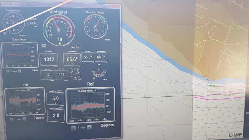
The winds were not as cooperative. Over an eight-week period, I saw only one or two decent weather windows, with the NW winds abating for a few days. It’s about 650 nm from Bodega Bay, where the KK was, to Neah Bay (just off the Pacific Ocean in the Straits of Juan de Fuca).  That means almost 5 full days on the eastern Pacific with no stops. It’s another day from there to Gig Harbor, but I didn’t worry about that portion of the trip. Once we got off the Pacific, we would be in sheltered waters and better able to deal with whatever Mother Nature threw at us.

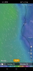
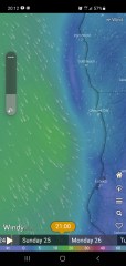
The weather window I was looking for, would have a low-pressure area and associated fronts, just off the coast, causing south to west winds at moderate strength. We needed to have a series of these lows, not just one, otherwise, upon frontal passage, with the low moving east, the high-pressure areas would build rapidly off the coast, bringing back the NW winds at 15 to 25+ knots off the coast.

That would be No-Go. My old body wanted no part of bouncing up and down the coast every 6 seconds for any number of days!

A few days before my anticipated flight from Wrangell to Santa Rosa, California, a two-day trip on Alaska Airlines, Ole called me to suggest a delay of 5 days, to better wait for our weather window. I was really happy to hear that, as I was looking at the same forecast conditions and was pleased that we were on the same page.

Looking 7 to 10 days out on Windy.com, it did seem that a weather window was developing for Saturday, April 24th. For the next week, the forecast stayed consistent, one of the best indications of a good forecast that has a good handle on the situation.

Sunday morning 02:00 fcst winds, approx 18 hours after our anticipated departure. We would be just SW of Mendocino, with winds off port quarter.

I arrived in Santa Rosa that Wednesday. The next day, we went to Svendsen’s Marine & Industrial Supply, a massive marine supply place in Alameda, that is worth the visit for anyone in the Bay area.

Sunday morning 08:00 fcst winds, approx 24 hours after our anticipated departure. We would be just W of Mendocino, with winds off port beam. (As fcst, this was our conditions for much of the night, with 12 to 18 knot WSW winds.

Friday, we spent provisioning, Ole was so generous in everything we bought and in fact we ended up buying far more food than we could ever eat, especially on a rolling ocean.

We were planning a Saturday morning departure, but it depended on the winds turning from the NW to the south, southwest or west.  While the forecast still called for this big change and had been consistent all week, the proof was going to be Saturday morning.

It was with much relief that I woke Saturday, checked the flags in the marina, and was pleased to see that they were finally streaming northward. Our much-anticipated southern winds had arrived. It was time to go.

Sunday morning 11:00 fcst winds, approx 27 hours after our anticipated departure. We would be just WNW of Mendocino, with light winds off port beam.

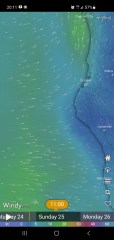
We couldn’t wait either, as the forecast winds were to become northerly again north of Eureka, California the following day. This meant we had to be north of that cape by the 24-hour point. It also meant that we would have strong westerly winds this first day, but those winds would become more southerly in subsequent days as long as we made progress north.

Now, a Kadey Krogen will roll on a damp lawn, and this boat had no stabilization. But neither did Dauntless my first year and 5,000 miles. A little rolling is good for the digestion in any case, and I was willing to put up with anything to avoid head seas and the hobby horse ride that entails on a full displacement boat.

As we left the harbor, we first had to go WNW for a few hours and then were able to turn NW to parallel the northern California coast. For much of the day, we had light southwest winds, with smallish seas off the port quarter. Again, this was just as forecast. As the day progressed, the winds were forecast to become stronger and more westerly for the nighttime hours. They did so that evening, so did the amount of our rolling. There was a cold front to our west, which caused the winds to increase to 12 to 18 knots. Seas built from less than one foot to 3 to 5 feet, so we were rolling like a … Kadey Krogen.

Sunday evening, 18:00 fcst winds, approx 45 hours after our anticipated departure. We needed to be off Eureka to stay east of the NW winds that were returning to be off shore.

That first day with any open water passages, when the boat gets rolling, any thing not secured would let its presence be known and they did. But this boat was pretty secured; Ole being an old sea dog. We had a line securing the refrigerator and freezer. The furniture was secured in the salon and we had re-stowed the loose stuff on the salon shelves.

The rolling increased that night, often up to 30° degrees to the lee side, 20° to the windward side, I was wedged into the pilothouse bench seat, having seen this movie before.

 A few things got loose anyway and as always; the noise is always worse than the damage (in a well-prepared boat).  A small container of fruits having escaped and spread over the floor that took some corralling. But the real damage was unseen for a number of hours.

This depiction for Sunday evening, 21:00, turned out to be reasonably accurate. We did have very light southerly winds that second night

What could that damage be?

As I said, Ole is a real Sea Dog, unlike me, who is just a neophyte in comparison. But the rolling took its toll, and the initial problem was unseen for hours. By the time, Olé did find the problem, it was a real mess.

A real mess.

Inside our refrigerator, a jar of preserves was unended, and horror of horrors, its lid came off, so it rolled around for hours that night with no lid, distributing its sticky contents everywhere over everything in the entire fridge.

It took poor Ole, hours to clean up the next day.

Guiltily, I thought to myself, better him than me, for a change.

I suppose there are upsides to being on someone else’s bottom.
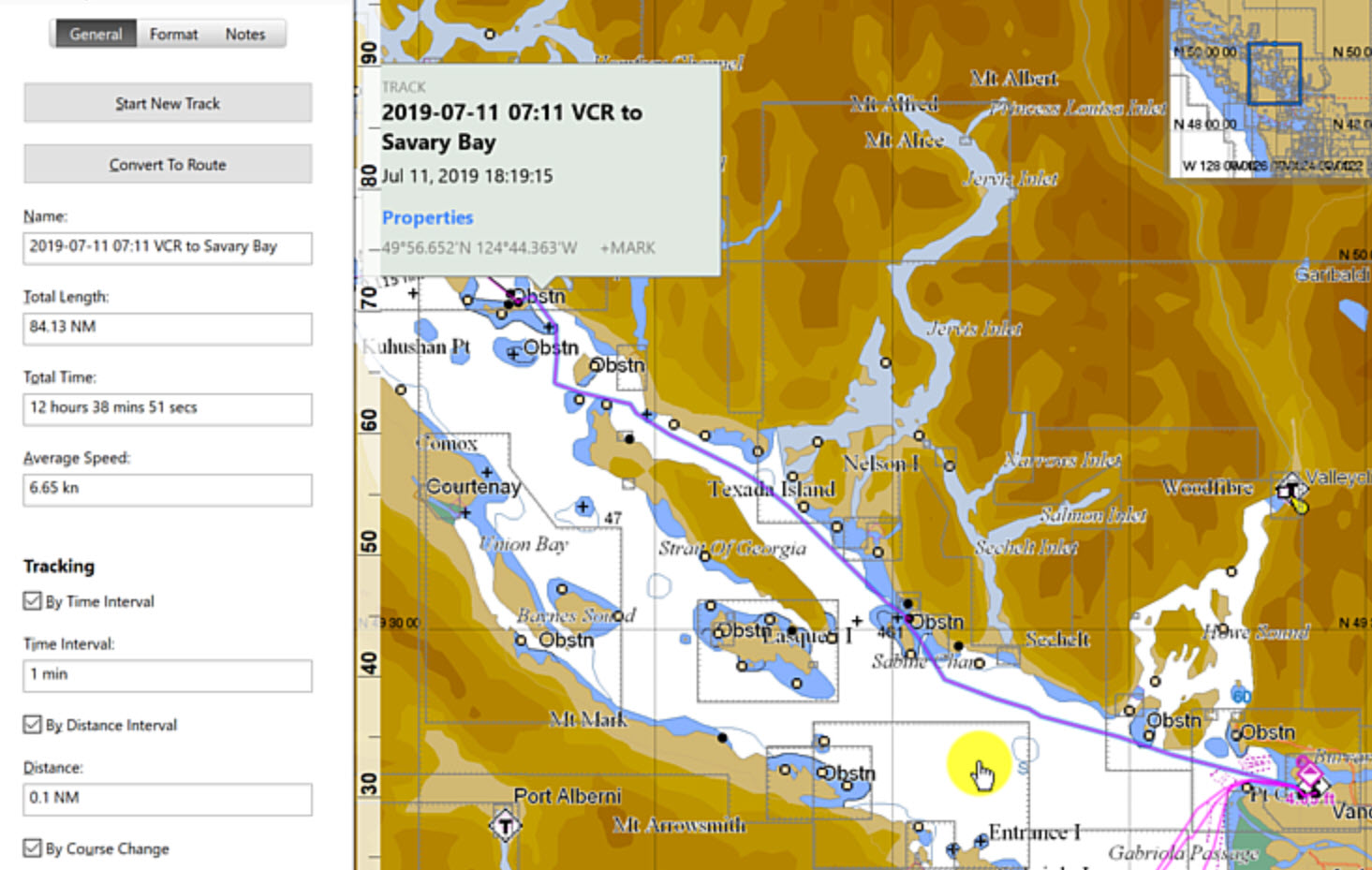
Advertisement

The Polar Bear Club

Hardy souls waiting to go for a dip.

I’m not in it, at least not in the Wrangell, Alaska version. Even NYC has a version, with people going in the water at Coney Island on the first of the year.

Now the Wrangell version is for these hardy enough to brave the cold waters (50°F) of Zimovia Strait on the first of the new year. This winter has been extremely wet, but not very cold, with temperatures staying above freezing except for just of couple of dry days in the high 20°s. Every other day we’ve had clouds and rain. Contrast that with last year, where by this time, we’d had few feet of snow since before Thanksgiving until now and had weeks of below freezing temperatures.

Our Marina on a rare sunny day

I do have my Polar Bear certificate for being in Resolute, Northwest Territories, Canada, but I just had to be there, not do anything special.

While on T-3, I did have the opportunity to jump into the Arctic Ocean, in the six-foot diameter hole we had melted thru the sea ice to collect zooplankton samples for the summer. But the idea of jumping into water that was 28°F, even then, in the years when I was young, brave and knew everything, was unappealing to me.

I pictured myself going into shock, not being able to drag myself out of our four-foot-deep ice hole, while my bumbling colleagues came up with a way to drag me out as I died of hypothermia.

Being on the Arctic ice pack in the middle of summer was fascinating. During the summer, with 24 ours of daylight for five months, the sun did produce significant melting of the top layers of ice.

Now, a little lesson on the Arctic ice pack. The ice pack was (until recently) only about 4 to 6 feet think, absent pressure ridges, (areas where the ice has been pushed into little hills by wind and current).  Currently, the ice pack has thinned to just 3 to 4 feet. Thus, much larger areas are opening up during the summer melt.

The ice pack grows from underneath, fresh water freezing in the 28° water. Thus, the ice pack is all fresh water and was the source of our drinking water. We melted ice most of the year, but for two months of the high summer, we would pump fresh water from the numerous lakes that formed on top of the ice.  These melt ponds would be a beautiful blue in color. On the other hand, when we would come upon leads (a break in the ice pack) in the ice, the water would be as black as the blackest night. I found them actually scary, I would not get within a few feet of them. Terrified would be more like it. Even after all these years, nothing has made me feel that primordial fear like those black, black leads.

The Arctic Ocean doesn’t get very much snowfall, it’s simply too dry. So, all the ice growth comes from below. While all the ice melt or sublimation (solid, ice, becoming gas, water vapor, without turning to liquid first. Sublimation is how most of the ice disappears. Therefore, the ice pack is always growing from underneath 10 months of the year and losing ice from above throughout the year, but especially in high summer, June and July.

If you would like to know more and be up on Arctic  Sea Ice News & Analysis, check out this link, which I look at every months as I dream of cruising from Alaska to Europe one day:

http://nsidc.org/arcticseaicenew

For a longer look at Wrangell’s New Year’s dunking, check out, (no translation needed):

Three Times Fail – Cabo Falso Beats Dauntless Like a Rented Mule

20180513 Three Times Fail – Cabo Falso Beats Dauntless Like a Rented Mule

Coastal Explorer chart with Maretron data overlaid

Cabo San Lucas was the most un-Mexican, unpleasant place I’ve been in the beginning of time or at least since I’ve been cruising Dauntless for the last 7 years.

It was expensive, literally, 3x to 10x more expensive than anyplace else I’d been in Mexico. The epitome of a tourist trap; I thought I was in Southern California.

Unexpectedly, Ensenada, being much closer to California, was truly charming. I could have been stuck there for months and been happy, conversely, being stuck in Cabo waiting for weather for 10 days felt like a year!

So, this video shows me attempting to leave Cabo just days after my arrival. I was now alone again; Larry was going to meet in the next week and I was hoping to be in Ensenada by then. Once making the right turn to the west at the very bottom of the Baja California peninsula, one heads due west to get around Cabo Falso, before turning northwest and then north to get up the coast. The winds are typically strong and right on the nose 15 to 35 knots. 15 is not pleasant, but is tolerable, high teems quickly becomes untenable for any length of time. Even under the best conditions, I would have a few hours of the strongest winds.

Sorry I don’t have more video of the worst moments, but when I’m being thrown around the pilot house, my last thoughts are on making videos.

Please remember to Like & Subscribe to my YOU TUBE videos, it makes YT like me better.

Anchoring on a Lee Shore in a Gale in Southeast Alaska – The Devil You Know…

20200725 Anchoring on a Lee Shore in a Gale in Southeast Alaska – The Devil You Know…

Our track around Farragut Bay ending in the east side of Read Island (as depicted by green boat)

As I have said before, this is my 7th year with Dauntless and 6 years with my 55# Delta anchor, so I sleep well at night on the hook.

We were cruising from Wrangell to Juneau, 148 nm, normally three days, but we wanted to do some halibut fishing and we didn’t need to be in Juneau until the following Wednesday, giving us 6 days.

We left Wrangell Friday morning on an out-going tide, giving us a push through most of Wrangell Narrows. Outside of Petersburg, at the north end of Wrangell Narrows, the current will abruptly change from a plus 1 knot to a minus 4 knot current. When this happens, we anchor just off the channel and wait a couple of hours for the slack. That’s what we did on this day also.

Even with our stop of a little less than two hours, we arrived in Farragut Bay about 20:00 Friday evening, dropped out shrimp pots and crab pot and anchored on the south side of the large bay. It is an open anchorage, but suitable for good weather with no swell.

We knew a storm was coming, with increased south-easterly winds throughout the day, Saturday and into Sunday. Our plan was to fish a bit  Saturday, check out another anchorage, but ultimately head to our Read Island anchorage where we had anchored two times previously, one time with very strong southerly winds (which meant we were anchored off a lee shore)

We fished a few spots, but no luck, as the winds picked up to 15 to 20 knots, the seas inside Farragut Bay did also, with 3-foot waves. We decided to pull our shrimp pots, which in hindsight turned out to be a mistake. It was not fun with those winds and waves and stressed Ti out more than was necessary.

We then headed to the east side of Read Island, where we could anchor for the night, but first did another hour of fishing in a spot Ti had noticed a small fishing boat last time we were here.

Saturday, 25 July 2020 at 18:00. Radar and chart depiction of our anchorage.

About 17:00 Saturday, we were anchored in our Read Island cove. I let out 140 feet of chain plus our 30’ nylon snubber bridle. The spot we anchored was roughly the same as the first time when we had seeked shelter here during another storm earlier this summer. The initial anchor bearing was 80’ @ 243° in winds that were already SE to SW at 8 to 15 knots.

The previous storm had produced winds 15 to 25 knots in this cove. I was quite stressed as it was a lee shore, but we pretty much stayed right where we anchored. This informed my opinion for this coming storm.

06:30 Sunday morning wind graph

We were anchored in 37 feet of water under the keel. Had it not been off a lee shore, I would have let out another 100+ feet of chain.

The winds were 15 knots gusting to 25 thru the evening. By nightfall, it was raining heavily and between the rain and the darkness, I could not even see the nearby shore a couple of hundred feet away off our beam. Thus, the lack of any decent videos or pictures.

Just before midnight the winds came down a few knots, but as they say, this was the proverbial calm before the storm, as by midnight, the winds were rapidly building again. It was to last almost 24 hours, with half that time with winds above 20 knots, peaking to 40.

This is our 24 hr wind graph from at 17:00 Sunday and the previous 24-hr to Sat 17:00 (when we first anchored)

I was happy to go to sleep before then, but Ti was a nervous nellie, waking me up every half hour to tell me the wind was blowing, and the boat was rocking a bit (though not really). The first couple of times I got up to check everything to maintain marital bliss, if nothing else, as it was pitch black outside, with heavy rain and wind. I could see nothing. At midnight, the anchor bearing was little changed in direction or distance.

While the winds were high in this cove, there was really no swell or waves, at most a half foot, making it a little rocky, but hardly noticeable in the scheme of things.

I went back to sleep, but Ti would still wake me up a dozen times until morning; I’d reassure here and go back to sleep.

Civil twilight was about 04:00, with sunrise 45 minutes later, so that’s when I got up again, as I could no longer use the excuse to Ti that it was dark out and I couldn’t see anything.

Ti makes the best of our SUnday by making an apple pie as we are hunkered down.

So I was up, in the pilot house, watching as the storm peaked about 06:00 with winds gusting to 40 knots and a steady 20 knots, but for the next 6 hours, while the wind gusts came down a bit,  the steady winds were higher in the 25 to 30 knot range. Thus, with that wind pressure, the anchor bearing distance oscillated between 156 and 174 feet for much of the morning, before decreasing to 110’ to 130’ by midafternoon. (and where it had been the previous evening).

My little diagram of our anchor in relation to the boat at its most extreme.

Looking at the little diagram I drew and my calculations, all the catenary was out at that point, 174 feet away, and we were simply being held by our Delta anchor. As the sun got higher in the sky ,I could see shallow rocks about one boats length away behind Dauntless. That confirmed my calculation to not let out more chain. I was also ready to start the engine should I notice us dragging. However, since we had not dragged at all, I was hesitating to move and thus possibly upset the balance we had obtained.

In analyzing the track on the Coastal Explorer C-Map chart and the Maretron wind graph, it was clear that we had spent about 12 hours between that 150 and 174 feet and by mid-afternoon Sunday, 22 hours after we had initially anchored, we had moved back to the original bearing and distance of 78 feet. Monday morning, when we finally hauled anchor after 36 hours, we had moved to within 60 feet of the anchor under calm winds.

The track of CE for 36 hours. The radius of the circle is 180′

All in all, I could not have been happier with how things developed and how rock steady we were under difficult conditions.

Would I do it all over again?

It’s hard to say. I would probably turn on the radar and set the alarms the next time. That would be more effective than anchor alarms (GPS based), which I don’t use anymore, because I find them ineffective.

My Alaska friends had told me that any location that may have been more sheltered from the wind would have been more open to waves and swell.

All in all, it’s hard to try to improve upon a good outcome. As they say, sometimes it’s better to stick with the Devil we Know, versus the one we don’t.

To see a little video of this, which I have not yet uploaded on my Dauntless at Sea You Tube channel, please visit the link  below and subscribe.

Dauntless at Sea You Tube Channel

20190717 Watts Narrows – No Guts, No Glory

Leaving Kutz Inlet Waterfall Earlier than Anticipated only to Tackle the Scary Watts Narrows by Day’s End

20190717 Kutz to Baker Inlet via Watts Narrows

As previously written, Dauntless got underway earlier than I. I woke up a little after 6 a.m. only to discover that we were about a ¼ mile from our anchoring spot We were a ¼ mile from where we were the previous night. I can determine from the Coastal Explorer track that we started drifting about 02:00, so in 4 hours we drifted a quarter of a mile down the inlet about ¼ mile from shore with depth now more than 200’.

Oops!

I started the engine and we got underway.

It was a typical summer day in the Inside Passage, cloudy with rain showers on and off all day. Once we got into the main channel, we had a quiet day moving north. About midafternoon, we were passed by a humpback whale heading south.

Three hours later, we were approaching Watts Narrows, which we needed to pass thru to enter Baker Inlet, where we would anchor for the night near yet another waterfall.

There are hundreds of passages called “narrow” in S.E. Alaska and British Columbia. Watts Narrows was the narrowest and scariest that I have encountered since Northern Europe!

I’ll let the two videos speak for themselves. I made videos from inside the pilot house showing the Coastal Explorer chart and the Raymarine radar, while also taking GO Pro video from outside.

Enjoy


Baker Inlet Waterfall


 Docking Dauntless at Heritage Harbor, Wrangell, Alaska

Docking Dauntless at Heritage Harbor, Wrangell, Alaska

We went to drop one crab and two shrimp pots. This video shows the last 15 minutes are we return to the Heritage Harbor, Wrangell, Alaska.

We back into our slip for the convenience being able to get on and off the boat via the stern and swim platform, plus it’s a little better for the shore power connections.

A few things to note: With a single screw and no bow thruster, Dauntless has always been a handful to get in and out of tight places. But as time as gone on and I’ve bounced off enough objects, I am pretty skilled at backing her up. She has a left-handed prop, meaning the prop rotates counterclockwise. This causes a produced prop walk to port, I have to keep about 3° of starboard rudder to go in a straight line.

She can turn 180° to port in about 60-foot diameter but turning to starboard can be problematic as I discovered one day while trying to turn on the River Maas in the Netherlands. While the current was against me, a 30-knot wind from our stern made turning around to starboard impossible as I discovered halfway thru the turn. The bow just stopped coming around. Luckily, at this point, I had plenty of room to turn the other way.

A couple of hours later, having already forgotten what I just learned, I tried again in a small harbor to dock into the wind.  (See the picture below ) To my horror, as the boat crabbed upstream and towards a boat tied perpendicular to the dock I was trying to reach, I rammed the dock with the bow, knowing that at least then, it would stop my progress towards this other boat 60 feet away.

Dauntless in Nijmegen. I had come on on the left (side of picture) to turn right to dock as you see, but wind was blowing 30 knots from astern (on the bow on).BTW, this was with a working bow thruster. Another reason I learned it’s best not to depend on one for when you really need it against high winds or current, it will be least effective.

Lesson learned.

Now when you see me make a 270° turn to port coming around to 90° to starboard from our original heading, you’ll understand why I take the long way around.

Here is my docking video


A look Inside at Dauntless, a Kadey Krogen 42, built in 1988

Dauntless Tour 2013 2020

The Wind is Always Blowing

A look Inside at Dauntless, a Kadey Krogen 42, built in 1988


I’ve been asked to give a little tour of Dauntless. Built in 1988 by Kadey Krogen, designed by James Krogen, this 42 foot boat has been the best economical paggagemaker of all time.

With two cabins, one mid-ship portside, the main forward, each with a head & shower. A very efficient boat inside and out.

Safe in towering seas, she just rolls along no matter what I ask her to do.


Cruising North along the Inside Passage in B.C. Kutz Inlet Waterfall Walkabout

20190716 Sloop Narrows, Klemtu Passage, Anchoring twice at Kutz Inlet Waterfall

Anchoring at Kutz Inlet Waterfall, Inside Passage, BC

Highlights of this day include:

  • Another beautiful day on the Inside Passage in British Columbia.
  • Passing thru Sloop Narrows, Klemtu Passage
  • Anchoring in front of Kutz Inlet Waterfall
  • Having to re-anchor because I had anchored on a steep underwater slope, so suspected the holding would not be good. It wasn’t.

Our first anchoring was at 17:46. We were anchored in 20’ to 32’ of water, as it was a steep slope. I suspected the anchor had not set on that slope, so I watched it carefully. Here is what I saw:

  • 17:46, Initial anchor bearing 48’@ 142°, depth under the keel, 32’
  • 18:01, (15 minutes later), bearing 35’ @204°, depth 15’
  • 18:15, 36’ @ 204° depth 12’
  • 18:30, 40’ @ 226° depth 7’

While the anchor was holding, I no longer liked the spot we were in. There were now two other boats in the anchorage, and they were more than a ¼ mile away. Maybe I better join them?

So, we moved. At 18:46 we were anchored in a new spot, much further from shore, but still on a slope. Bow anchor bearing was now 72’ @ 248°, I had 90’ of chain out in 40’ of water. I decided to put the stern anchor out. It’s a plow anchor with 10’ of chain and 300’ of nylon rode. This was just in case the bow anchor was not well set on the slope it was on.

For the next two hours I watched it. With two anchors out, I used the waterfall itself as a reference. The distance did not vary by more than 15 feet, I felt this was OK. Though our depth under the keel continued to lower as the tide went out. And because I had two anchors out, I did not have much scope on either line, with only about a 100’ out for each in 30’ of water.

But I wasn’t worried and with 12’ under the keel, I went to sleep, planning on an early departure the next day, so we could get to Prince Rupert, BC in two days.

I slept so very well. In my first years anchoring, I would awake every couple of hours, lay in bed feeling the motion and within a minute, convince myself that we were float free and clear. I’d then check the anchor alarm (Drag Queen), notice that it had turned itself off, so would get up to check that all was good. It always was good. In other words, my imagination was worse than the reality. I then go back to sleep, only to repeat the process a couple of hours later.

By years 3 & 4, waking up became less routine on the hook, as my 55# Delta anchor never dragged. Though I would still check occasionally in the worst weather.

This highlighted track shows the route we took when Dauntless got impatient and left.

In the last couple of years, I’ve become even more relaxed about anchoring. Having used the anchor alarm in years, mostly because I found it only went off, after I took the dingy to shore and was walking downtown. Additionally, my first-year anchoring miscues were not so much about the anchor dragging, but me anchoring in the wrong place with not enough water under the keel at low tide.

I wouldn’t call it complacent, I was finally just comfortable anchoring, knowing my boat and anchor. To a point where even last month, on our trip to Juneau, we had to shelter from a first storm in Farragut Bay. We anchored in a little cove that I had anchored in two times previously. While it was a lee shore, in that the wind was pushing us towards the shore just behind the boat.

All thru the night, Ti would wake me up every 20 minutes to tell me the wind was blowing as the boat rocked back and forth. The first time I did get up to check, but with 40 knot winds and rain, I couldn’t see anything, but could tell from the chart we were 172’ from the anchor, just where it was when I went to bed. I didn’t get up again.

Writing about this now, I will make my next video of this day, so you can see the charts.

Back to our story.

I woke up at 6 the next morning and almost always immediately upon waking up, I would get up and do a quick check even before I put any clothes on.

This morning, I knew we wanted to get underway, so I figured I’d take the 10 minutes to do my morning toilet, get dressed, then haul anchor, get underway and make coffee.

That plan worked so well.

So well in fact, that I even went into the engine room to check the oil level before I came up to the pilot house. Larry was still sleeping in his cabin, when I looked out the pilot house windows and  noticed we were already underway!

We were a ¼ mile from where we were the previous night. I can determine from the Coastal Explorer track that we started drifting about 02:00, so in 4 hours we drifted a quarter of a mile down the inlet about ¼ mile from shore with depth now more than 200’

I figured Dauntless was in a hurry to get underway, so I obliged her.


North on the Inside Passage in BC, Bella Bella to Mouat Cove and onward thru Reid Passage

Hecate Strait to the west. The magenta line (on the right) is the route we took up the Inside Passage

20190715 North on the Inside Passage in BC, Bella Bella to Mouat Cove and onward thru Reid Passage.

The chart shows why the Inside Passage is so special, sheltering one from hundreds of miles of open Pacific ocean swells and waves.

Highlights of this day and a half include:

  • Another beautiful day on the Inside Passage in British Columbia.
  • Anchoring in Mouat Cove
  • We take the dingy for a short spin
  • Departure from Mouat Cove
  • Going through the narrow passage of Reid Passage

    Mouat Cove

We took the dingy out to explore Mouat Cove, a beautiful little stop about midway along the Inside Passage. We managed to not hit any rocks, wither with the dingy or with Dauntless.


20190713, 14 & 15 Blenkinsop Bay to Sea Otter Creek to Bella Bella BC

On these two and a half days, 13, 14 and 15 July 2019, Dauntless continues her northward trip up the Inside Passage in British Columbia to Alaska.

Highlights of this day include:

  • We race the Alaskan Ferry Columbia
  • We have a freshwater leak that empties our only full water tank
  • We stop early to rebuild the water maker, which only takes about 4 hours, only to discover that it didn’t solve the problem
  • Each day was 65 nm in 9 hours and 30 min on the 13th and just over 10 hours on the 14th.
  • First half of day 3, was just from Sea Otter Inlet to the Bella Bella dock where we hoped to get water for our freshwater tanks.

Low lights consisted of us spending 6+ hours rebuilding the Katadyn watermaker high pressure pump only to discover it did not solve the problem of the oil seal that was in the electrical motor portion of the water maker.

Upon close inspection, I had suspected as much before we started, but I was hoping for one of those boating miracles that was not to be.

For some reason, there does not seem to be a lot of places to stop and get fresh potable water along the BC portion of the Inside Passage.  The cruising guide did seem to indicate that water was available at Bella Bella, so that was our destination on the morning of the 15th.

Once docked, we found the hose, but it took me 15 minutes to figure out how to turn on the water. The valve was hidden just beyond alittle gate that made it difficult to see.

Once that was done, we filled both tanks and got underway to anchor for the night a few hours north in Mouat Cove.

Here is the video: Dauntless in the Inside Passage 13 July 2019

20190712 Savary Island to Blenkinsop Bay via Campbell  River and Johnstone Strait

The tile says it all. This is the 12 July 2019 cruise on Dauntless northbound the Inside Passage in British Columbia.

Highlights of this day include:

  • We see a small whale
  • We see numerous whirlpools, but don’t get sucked in
  • We pass a number of southbound cruise ships, including the Nieuw Amsterdam and the Alaska Ferry Kennecott. ( I have a fondness for the Holland-America line, as I grew up across the street from Pier 40 in New York, where they docked in the 1950’s up until the 80’s?.
  • We stop for three hours on the Campbell river to wait for the currents to change.
  • Larry corrects me when I say “Johnston” Strait not “Johnstone”. Made all the funnier for me because I should have known, having been once married to a Johnstone.
  • Our anchorage was pretty windy, with westerly winds of 20 knots gusting to 28. But we held well as we always do (well until a few days later, but that’s another story.

Here is the video: 20190712 Savary Island to Blenkinsop Bay via Campbell  River and Johnstone Strait

20190711 Vancouver BC to Savary Island with tour of Smuggler Cove

We left Vancouver BC for the last time at 7:11 on 7/11. I think it was a coincidence! It was a long, 12+ hr. day, but it’s the Inside Passage, so weather is normally not a factor.

Dauntless cruise from Vancouver BC to Savary Bay 11 July 2019

There was an interesting spot we (My long-time Alaska friend Larry was with me for the next two weeks) wanted to check out, Smuggler’s Cove and that turned out to be the highlight of the day. Truly tight and narrow, it was a bit stressful entering and even leaving.

We have some OK Go-Pro footage of that excursion, though the Go Por was fogging up, so it’s not as good as it should be. I also took some video from inside the pilot house of the charts, both my Coastal Explorer running C-Map and Navionics on my tablet.

After that exploration, it was another 7 hours until we stopped for the night in an open anchorage, just north of Savary Island. All in all, as easy day, filled some interesting tidbits.

You can watch the videos here on the Dauntless at Sea You Tube Channel. The Smuggler Cove entrance is very tight and the conversation between Larry & I is interesting. Vancouver BC to Savary Island with tour of Smuggler Cove

Larry has been on Dauntless crossing the English Channel, Leaving Cabo San Lucas and the Mexican coast northward and now from Vancouver in the Inside Passage. This latest cruise was the easy compared to the rough sea we experienced off the Mexican coast and in the English channel. Those videos will get uploaded after I finish the Inside Passage 2019.